Exploring two major highlights of a world-renowned trekking destination in a single trip, Everest Base Camp (5,364m/ 17,598ft) and Gokyo Lakes (4,800m/ 15,748ft)
Breathtaking summit views from Gokyo Ri (5,357m/ 17,575ft) and Kala Patthar (5,550m/ 18,208ft)
Standing beneath the foothills of the highest peak in the world and relishing the surreal, magical atmosphere
Exploring the series of glacial lakes, Gokyo Lakes, the highest freshwater lake system in the world
Crossing the dramatic Cho La Pass (5,420m/ 17,782ft), a rugged glacial-line saddle that connects Gokyo Valley with the Everest trail
Introduction to both mainstream and remote, less-commercialized Sherpa villages that are rich in culture and hospitality
Inclusion of Gokyo Valley offers a much more peaceful and uncrowded Himalayan experience
Traversing the diverse landscape of the country from lush rhododendron forest and roaring river to massive glaciers, icy moraines and high-altitude barren moonscapes
Rich biodiversity in Sagarmatha National Park, a UNESCO World Heritage Site that is home to the Himalayan tahr, musk deer, snow leopard and pheasant
Trip Overview
The Everest Base Camp Gokyo Lakes Trek is a legendary Himalayan journey that combines the classical EBC trail with a breathtaking detour to the turquoise Gokyo Lakes. This journey takes you across one of the dramatic high Himalayan passes, Cho La Pass (5,420m/ 17,782ft). Everest Base Camp via Gokyo Ri is not just a trek, it is an immersive experience into the spiritual heart of the Khumbu region.
This duo-itinerary exploration combines world-famous destinations like Namche Bazaar, Everest Base Camp, Kala Patthar, Gokyo Lakes and Gokyo Ri into one unforgettable adventure. Unlike the standard route, this variation takes you off the beaten path through remote Sherpa villages like Dole, Machhermo and Phortse. So, you will get a chance to admire and soak in the culture and lifestyle of the beautiful mountain settlement in both the mainstream route and the isolated valleys.
What sets this route apart is the dramatic shift in terrain. You transition from the bustling Khumbu highway to the quieter and mystical Gokyo Valleys. Unlike the dense pine forests and teahouses-lined trails of the mainstream EBC path, the Gokyo side offers a wilder and more pristine landscape.
In every step, the Everest Base Camp with Gokyo Lake Trek offers contrasts between crowd and solitude, culture and nature and the classical trail and the less-traversed hidden gems. This journey is especially designed for those who want more than just to reach the base camp. It's for those free spirits who want to feel the soul of the Himalaya through its diverse terrains, sacred valleys and true mountain essence.
Everest Base Camp Gokyo Lakes Trek Itinerary Plan (Outline)
Below is the day-by-day breakdown of the Gokyo Lakes and Everest Base Camp itinerary, designed to give you a clear picture of the journey’s elevation gain, daily walking distance and key highlights along the way. This 14-day itinerary of Eco Holidays Nepal blends adventure with proper acclimatization, ensuring a safe and enriching experience.
This short itinerary plan outline summary gives you a quick glimpse of what you can expect in terms of elevation profiles, trek duration and terrain variation throughout the trek.
Day
Everest Base Camp Gokyo Lakes Trek Itinerary Plan
Elevation Profile
Duration/ Distance
01
Flight to Lukla (2,860m/ 9,383ft) from Kathmandu and trek to Phakding (2,610m/ 8,562ft)
1,460m/ 4,790ft (gain)
Flight Distance: 138km/ 85 miles Flight Duration: 35 minutes Trek Distance: 8km/ 4.9 miles Trek Duration: 3 to 4 hours
02
Trekking to Namche Bazaar (3,440m/ 11,286ft)
830m/ 2,723ft (gain)
Trek Distance: 12.3km/ 7.64 miles Duration: 5 to 6 hours
03
Acclimatization day in Namche
04
Namche to Dole (4,038m/ 13,248ft) trek via Phortse Tenga
598m/ 1,961ft (gain)
Trek Distance: 12km/ 7.45 miles Duration: 6 to 8 hours
05
Trek to Machhermo (4,470m/ 14,665ft)
432m/ 1,417ft (gain)
Trek Distance: 6km/ 3.72 miles Duration: 5 to 6 hours
06
Machhermo to Gokyo Lake (4,800m/ 15,748ft)
330m/ 1,082ft (gain)
Trek Distance: 9km/ 5.5 miles Duration: 5 to 6 hours
07
Early morning hike to Gokyo Ri (5,357m/ 17,575ft) and trek to Thangnag (4,700m/ 15,419ft)
575m/ 1,886ft (gain)
Trek Distance: 5km/ 3.1 miles Duration: 4 to 5 hours
08
Crossing Cho La Pass (5,420m/ 17,782ft) to reach Dzongla (4,830m/ 15,846ft)
720m/ 2,362ft (gain)
Trek Distance: 11km/ 6.8 miles Duration: 7 to 8 hours
09
Dzongla to Lobuche (4,910m/ 16,108ft)
80m/ 262ft (gain)
Trek Distance: 6.5km/ 4.03 miles Trek Duration: 4 to 5 hours
10
Trek to Everest Base Camp (5,364m/ 17,598ft) via Gorakshep (5,164m/ 16,942ft)
454m/ 1,489ft (gain)
Trek Distance: 11.5km/ 7.15 miles Duration: 8 to 9 hours
11
Morning hike to Kala Patthar (5,550m/ 18,208ft) and trek to Pangboche (3,900m/ 12,795ft)
386m/ 1,266ft (gain)
Trek Distance: 15.2 km/ 9.44 miles Duration: 7 to 8 hours
12
Pangboche to Namche Bazaar (3,440m/ 11,286ft)
460m/ 1,509ft (loss)
Trek Distance: 13.8km/ 8.57 miles Duration: 6 hours
13
Trek back to Lukla (2,860m/ 9,383ft)
580m/ 1,902ft (loss)
Trek Distance: 17.9km/ 11.1 miles Duration: 6 to 7 hours
14
Fly back to Kathmandu (1,400m/ 4,593ft) and a leisure day
1,460m/ 4,790ft (loss)
Flight Distance: 138km/ 85 miles Duration: 35 minutes
Trek Map and Elevation Profile
Our Everest Base Camp elevation chart for the Gokyo Lakes and Everest Base Camp itinerary gives you a clear picture of how the trek gradually ascends and descends across the high-altitude terrain. We have listed the elevation of all the major destinations from the low valleys of Lukla to the towering height of Gokyo Ri, Cho La Pass, Everest Base Camp and Kala Patthar.
This Everest Base Camp and Gokyo Lakes Trek map and altitude profile help you understand the daily altitude gains and losses, allowing for better planning and acclimatization awareness. Also, by visualizing the journey’s ups and downs, you can prepare both mentally and physically for what lies ahead.
Cost Details
What's Included in Everest Base Camp Gokyo Lakes Trek
Airport pickup and drop-off by private vehicle.
Three meals a day (breakfast, lunch, and dinner) during the trek.
Trekking lodge (tea house) accommodations throughout the trek.
All necessary paperwork: Sagarmatha National Park entry permit and Trekker’s Information Management System (TIMS) permit.
Kathmandu-Lukla-Kathmandu flight with private airport transfer and domestic airport tax.
A highly experienced, helpful, knowledgeable, friendly, English-speaking, well-trained, government license holder guide. With all his salary, food, drinks, accommodation, transport, and insurance.
Comprehensive medical supplies (first aid kit will be available)
Arrangement of emergency helicopter service (paid by your travel insurance company).
Use of sleeping bag, down jacket, duffel bag, and walking poles. (If you don’t have your own, you need to return them after the trip is completed.).
Eco Holidays Nepal T-shirt and cap.
Government taxes and official expenses.
Everest base camp trekking map.
An oximeter to check your pulse, oxygen saturation, and heart rate twice daily (very useful to check altitude mountain sickness (AMS) symptoms), which will ensure your trek is in the safest hands possible for all levels of trekker.
Assistant guide group size above 6 persons.
What's Excluded in Everest Base Camp Gokyo Lakes Trek
Meals whilst you are in Kathmandu, lunch and dinner.
Your Travel and Medical Insurance.
Kathmandu Hotel.
Porter if needed ($280)
International Airfare.
Your Personal Expenses.
All the alcoholic and nonalcoholic cold and hot drinks on the trek.
All desserts are sweet things like chocolate, cake, pie, and pudding.
Hot shower and battery charging on the tea houses.
Kathmandu sightseeing $90 car and guide.
Price & Availability
Group Discount Available
1 Person
US$ 1510
2 - 5 Person
US$ 1350
6 - 10 Person
US$ 1275
11 - 16 Person
US$ 1225
Itinerary of Everest Base Camp Gokyo Lakes Trek - 14 days
Day 01
Flight to Lukla (2,860m/ 9,383ft) from Kathmandu and trek to Phakding (2,610m/ 8,562ft): 35 minutes flight and 3 to 4 hours trek
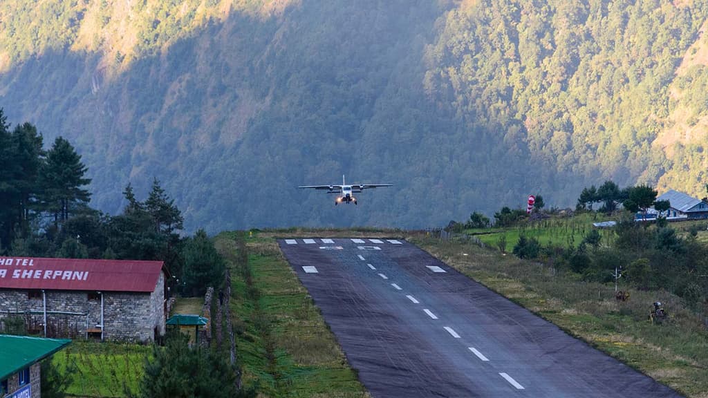
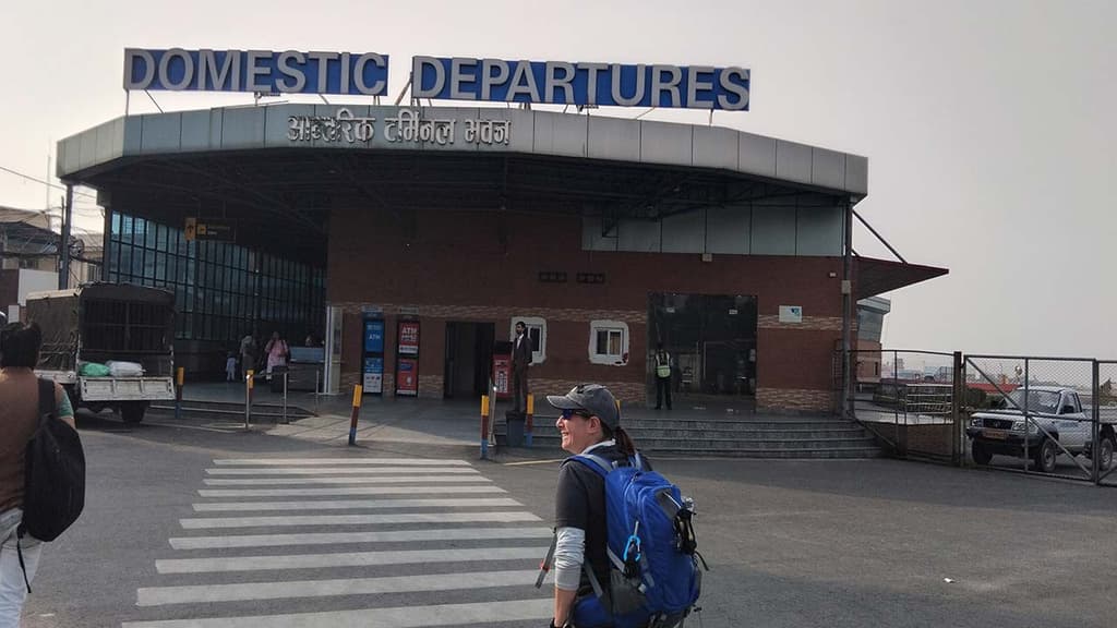
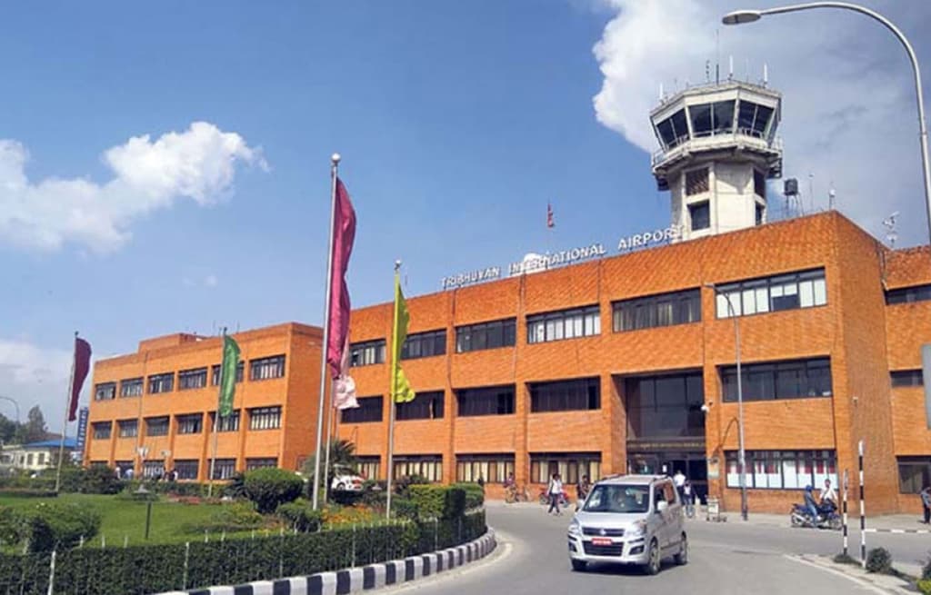
Your Everest Base Camp Gokyo Lakes Trek adventure begins with an early morning flight from Kathmandu to Lukla. It is a short but thrilling hop that offers stunning aerial views of the deep river valleys, terraced hills and the glimmering Himalayan peaks in the distance.
After landing at Tenzing Hillary Airport, you will take a break for breakfast and meet up with your porters before continuing with the trekking part. You follow the well-trodden stone trail out of the village that gradually descends to Chheplung Village.
This is a charming hamlet with mani stones, carved boulders and traditional Sherpa homes. The journey continues toward another quiet settlement, Thado Koshi Gaon. Enjoying the striking views of Kusum Kanguru, you will then head toward Ghat Village.
From this culturally vibrant settlement, the trail undulates gently before a short climb and descends toward Phadking Village. This beautiful village is located along the banks of the milky Duhd Koshi River and surrounded by pine forest.
About Flight Re-Routing
There is a high probability of the Kathmandu to Lukla flight getting re-routed during the peak season months, like March to May and September to November. This is due to the influx of in the number of trekkers for this mainstream route. So, in such a case, you will have to fly from the alternative route, Manthali Airport, Ramechhap.
As the drive to Manthai Airport from Kathmandu takes about 4 to 5 hours, you will need to wake up at around 2:00 to 3:00 AM for the drive. Or, you can travel to Ramechhap a night early and take the morning flight to Lukla.
If you want to skip this flight re-routing, you also have the option to take a helicopter flight from Kathmandu to Lukla. The cost of a helicopter flight from Kathmandu to Lukla is approximately US$ 500 per person. However, as we will refund your ticket cost for the plane flight (US$ 200), you will just need to add US$ 300 to take this helicopter flight.
*Note: The cost for helicopter flight will vary depending on the number of passengers in the off-seasons (there are only a few trekkers in the region). If there are not enough trekkers, you can take the charter, which will cost around US$ 2,500 to US$ 3,000**
Max. Elevation:2860
Duration:35 minutes(flight) and 3 to 4 hours(trek)
Distance:138km(flight) and 8km(trek)
Day 02
Trekking to Namche Bazaar (3,440m/ 11,286ft): 5 to 6 hours
After a peaceful night beside the cascading Dudh Koshi, you will begin your ascent journey toward Namche. First, the trail out of Phakding weaves in and out of the lush pine forests. Following the riverbank gently, you will climb toward Toktok Village.
On a clear morning, you can enjoy the breathtaking views of Thamserku from this stretch. Soon after, you will cross another charming hamlet of Benkar with traditional stone houses. A short walk beyond Benkar brings you to a stunning suspension bridge above the soaring Dudh Koshi.
After crossing the suspension bridge, you will follow the winding rocky trail to Chhamuwa Village. Then, you will make your descent toward Monjo Village, the gateway of Sagarmatha National Park. This is where your permits and checked and stamped.
Beyond Monjo lies Jorsalle Village, the last settlement before Namche. This riverside village is a perfect stop for lunch, it has a handful of lodges and resting posts. Past Jorsalle, the trail follows Dudh Koshi once more and you will arrive at the base of the Hillary Suspension Bridge.
Across the bridge begins the long and steep ascent. You will follow a winding uphill climb through conifer forest and rocky terrain. From about halfway, there is a scenic viewpoint which offers the first glimpse of Mount Everest, peeking from behind the shoulder of Lhotse.
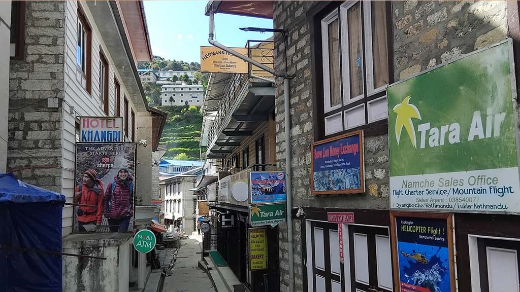
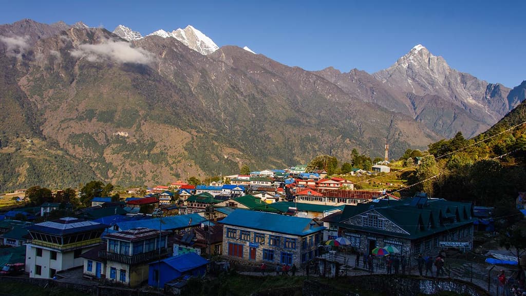
The path further ahead snakes along the contour and you will finally arrive at Namche Bazaar. This is the largest and most vibrant town in the Khumbu region. It is the bustling hub of trekkers, locals, marketplaces, restaurants, bakeries and mountaineering history.
Max. Elevation:3440
Duration:5 to 6 hours
Distance:12.3km
Day 03
Acclimatization day in Namche
This day’s adventure in Gokyo Lakes and Everest Base Camp itinerary is all about acclimatization. You need to give your body enough time to adjust to the thinning air before gaining more elevation. Although it is a rest day, it doesn’t mean that you will stay idle.
After breakfast, most trekkers follow the ridge trail above Namche to Sagarmatha National Park Museum and Viewpoint. This is a perfect panoramic spot to enjoy the stunning views of the Himalayan peaks. Just above the viewpoint is the Sherpa Culture Museum, where you can explore the traditional Sherpa architecture, tools and mountaineering artifacts.
For those who are energetic, a highly recommended hike continues toward the Everest View Hotel (3,880m/ 12,729ft), one of the highest placed luxury hotels in the world. From this hotel, you can catch the jaw-dropping views of Everest, Ama Dablam, Nuptse, Lhotse, Taboche, Khumbila, Kusum Kanguru and Kangtega.
If you want to extend your acclimatization hike further, the path beyond the hotel leads to the twin Sherpa villages of Khumjung and Khunde. On your return to Namche, you can explore the Sherpa town more deeply, visiting local bakeries, coffee shops, gear stores of the lively Saturday Marketplace if your day aligns.
Max. Elevation:3440
Day 04
Namche to Dole (4,038m/ 13,248ft) trek via Phortse Tenga: 6 to 8 hours
Leaving Namche behind, you follow the path north that climbs on a gradual slope with clear glimmering views of Everest, Lhotse and Ama Dablam in the background. You will stay on the classical Everest Base Camp Trekking route until reaching Kyangjuma Village.
Following the trail further ahead, you arrive at SanasaVillage. Here, the trail splits two ways; the right-hand path descends to Tengboche and Everest Base Camp, while the left one veers toward the quieter Gokyo Valley Trail.
You will follow the one on the left and walk across the winding path through a dwarf rhododendron forest and moss-covered boulders. Then, the short and steady descent will bring you to Phortse Tenga. This is a peaceful riverside village that is at the confluence of Dudh Koshi and Imja Khola.
After crossing a wooden bridge over the river, you follow the uphill route through the rhododendrons and birch forests to reach Dole Village. This section feels magical during the spring season when the peak blossom paints the path pink and red.
Dole is a beautiful and quiet windswept settlement with few stone-built lodges and yak pastures. As you will feel altitude more distinctly here, it is important to keep the pace slow, stay hydrated and allow your body to settle.
Max. Elevation:4038
Duration:6 to 8 hours
Distance:12km
Day 05
Trek to Machhermo (4,470m/ 14,665ft): 5 to 6 hours
This day’s trek begins with a gentle climb out of Dole toward the north. The treeline makes way to low alpine shrubs, juniper bushes and wide yak pastures. As the trekking trail ascends gradually, you will find yourself surrounded by the high walls of rock and snow as the Cho Oyu starts to appear in the distance.
You will gradually push for Lhabarma, a seasonal herding outpost. From here, the trail continues to stretch uphill, crossing segments of exposed rocks and scattered boulders. A walk a little further ahead will bring you to Luza. This is a picturesque resting point in the Gokyo Valley trek route that overlooks the Dudh Koshi far below.
As you climb above Luza, the trail hugs the side of the mountain, which slowly unveils the epic views og Thamserku, Kantega and glacier-carved hillsides below. You will also see carved mani stones and chortens along the trail, which are the spiritual markers that guide the way for the travelers in this remote highland.
Finally, you arrive at Machhermo, which is a beautiful, windswept plateau that is surrounded by steep rock faces and snow-dusted ridges. This small village has few lodges, yak shelters and the Himalayan Rescue Post, which provides knowledge about altitude sickness during peak trekking seasons.
Machhermo is also known for its folklore; it is believed that Yeti attacked several yaks and people here in the 1970s. These stories add a touch of mystique to this serene Himalayan valley.
Max. Elevation:4470
Duration:5 to 6 hours
Distance:6km
Day 06
Machhermo to Gokyo Lake (4,800m/ 15,748ft): 5 to 6 hours
As you leave Machhermo behind, the trail gradually climbs along the west bank of Dudh Koshi River. Beyond this point, the trail is now fully alpine, dry, rocky and wide with expansive views in every direction.
The snow-clad ridgelines, distant glaciers and the icy winds will remind you that you have truly entered the high Himalayas. The first stretch of the trail rises steadily to a ridge right above Machhermo with striking views of the valley toward the back. As you climb higher, Cho Oyu becomes more dominant on the northern horizon.
Next, you will pass Phangka, a wide flat grazing area that was once devastated by an avalanche in 1995, which claimed 40 lives. From Phangka, the trail descends briefly to the riverbed and you will cross a wooden bridge over the glacial stream.
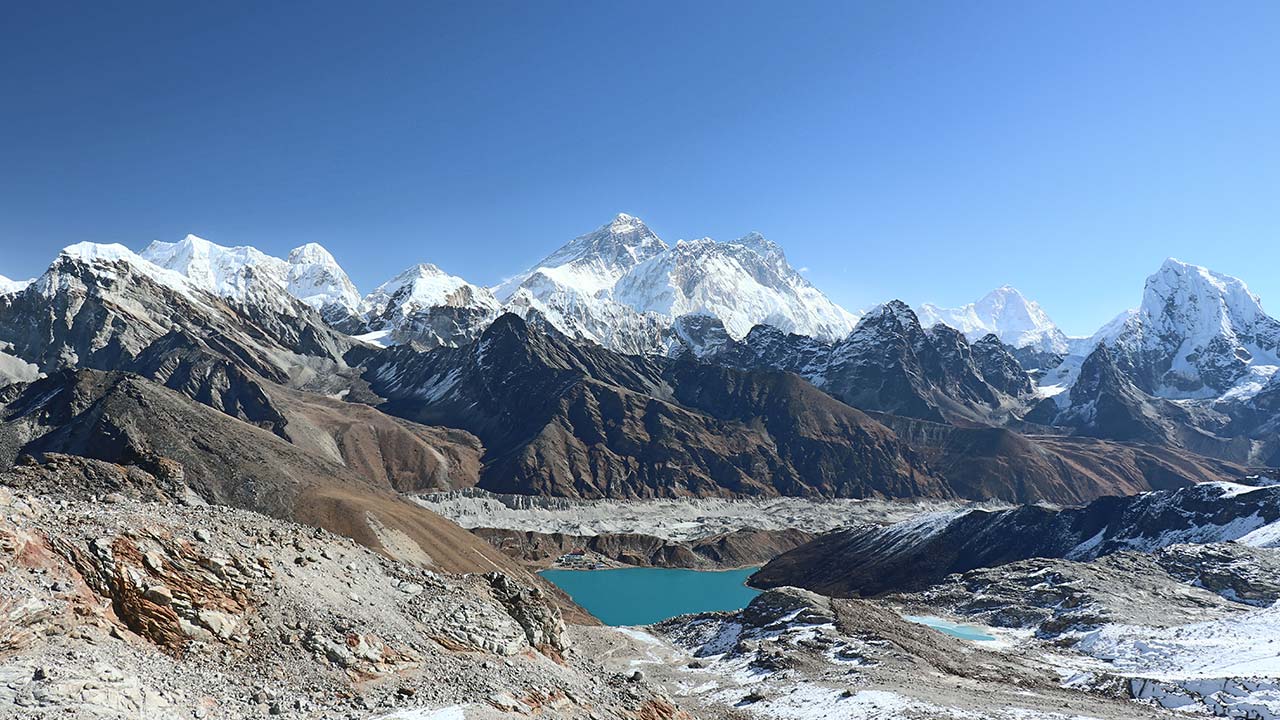
Then begins the zigzagging climb up the moraines of the Ngozumpa Glacier, which is spread across an area of 36 km (22 miles). From the top of the moraine ridge, the first of the Gokyo Lakes, Longpongo, becomes visible.
A short walk further ahead takes you to Taboche Tsho, the second lake, glimmering with a blue hue beneath the rugged cliffs. From here, the trail continues along the lakeside with panoramic mountain views and takes you to Dudh Pokhari, the third and main lake of the series.
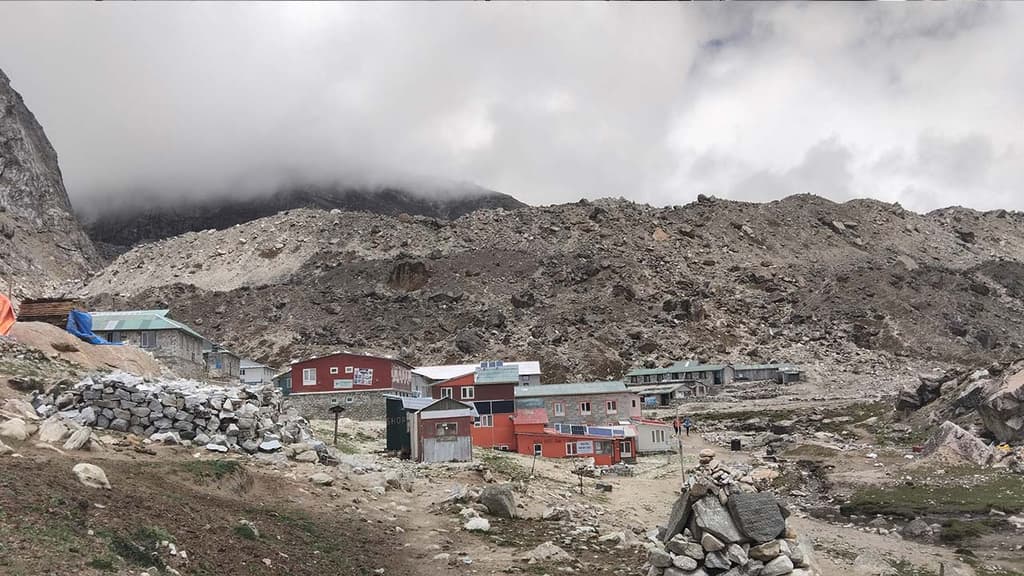
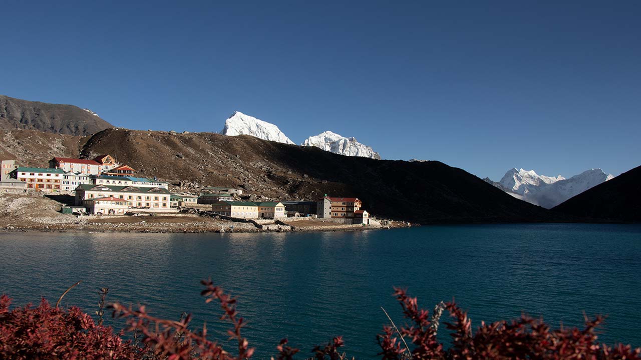
The Gokyo Village is located on the eastern shore of Dudh Pokhari with a backdrop of Cho Oyu and Ngozumpa Glacier. This village has a small cluster of stone lodges with green or blue tin roofs dotting the shoreline. As you will arrive early, you will have enough time to rest, explore the lakeshores, or hike a little higher for acclimatization.
Max. Elevation:4800
Duration:5 to 6 hours
Distance:9km
Day 07
Early morning hike to Gokyo Ri (5,357m/ 17,575ft) and trek to Thangnag (4,700m/ 15,419ft): 4 to 5 hours
On this day of your Everest Base Camp Gokyo Lakes Trek itinerary, you will begin your pre-sunrise climb to Gokyo Ri. This is a steep ridge above the Gokyo Lakes that offers one of the most spectacular panoramas in the Khumbu.
The hiking trail starts behind the Gokyo Villages and winds along dusty switchbacks. As you climb higher, the views gradually open up, first Gokyo Lakes, then the whole Gokyo Valley and the jagged line of ice and rock of Ngozumpa Glacier.
After about 1.5 to 2 hours of ascent, you finally reach the summit of Gokyo Ri. From here, the 360° view of Everest, Lhotse, Makalu, Cho Oyu, expansive Ngozumpa Glacier, sparkling Gokyo Lakes and distant ridgelines stretching to Tibet feels surreal and breathtaking.
You can take your time to soak in the moment and click photographs. After that, you will carefully descend back to Gokyo Village for a hearty breakfast. Then, later in the morning or early afternoon, you will begin your journey toward Thangnag.
The trail from Gokyo to Thangnag stretches across the labyrinth of loose rocks, shifting moraines and icy crevasses. You will feel the crunch of glacier gravel beneath your boots as you move along the trekking trail.
There is no permanent village on this route; thus, you can immerse yourself in the Himalayan beauty in its rawest form. After about 1.5 to 2 hours of traversing, you arrive at Thangnag Village. This is a small settlement that is perched beneath steep cliffs and glacial ridges.
Thangnag is only a basic functional stopover used by the trekkers preparing themselves for crossing Cho La Pass the next day. You will spend your evening here resting, hydrating and preparing your gear for a big day of adventure ahead.
Max. Elevation:4700
Duration:4 to 5 hours
Distance:5km
Day 08
Crossing Cho La Pass (5,420m/ 17,782ft) to reach Dzongla (4,830m/ 15,846ft): 7 to 8 hours
This day’s adventure also begins well before sunrise. Departing from Thangnag, you move along the route that gently heads eastward up a wide glacial basin. The path is dotted with boulders and snow patches.
As you ascend higher, the surrounding cliffs close in and create a dramatic amphitheater of rock and ice. You need to walk about an hour to reach the base of the Cho La ascent. From here, the trail steepens significantly and zigzags up the rugged slope of loose rock and icy patches.
The final stretch on the pass to the summit involves scrambling over rocks. In the colder months, it may be necessary to traverse across compact snow or even ice. Thus, microspikes or crampons may be essential depending on the conditions.
Finally, you arrive at the top of Cho La Pass, a narrow notch between the towering rock walls, which is adorned with fluttering prayer flags. From the top of the pass, you can admire the stunning views of Cho Oyu, Ngozumpa Glacier, Thamserku and Arakam Tse on the west side.
As for the eastern side, the views of Cholatse, Taboche and Lobuche East and West will celebrate your arrival. After enjoying your time at the top of the pass, you will prepare for your descent. First, you will traverse a small glacier field just below the pass. Be careful with your footing as the trail here can be slippery and partially covered in snow.
After that, the glacier path becomes rocky and winds down into the valley below. At the bottom, the terrain eases into a rocky meadow scattered with boulders. In the final stretch, you will traverse beneath the looming north face of Cholastse to reach Dzongla.
This is a small village with lodges that are perched on the grassy shelf above the valley. The views of Ama Dablam and Taboche from here are breathtaking. After an intern day of trek, Dzongla is a perfect place to recover, rehydrate and reflect on your journey so far.
Max. Elevation:4830
Duration:7 to 8 hours
Distance:11km
Day 09
Dzongla to Lobuche (4,910m/ 16,108ft): 4 to 5 hours
You will begin your trek here with a gentle start, leaving the windswept lodges of Dzongla. Compared to the past few days’ trekking route, this day’s route feels much less strenuous. Still, the terrain remains high and exposed.
From Dzongla, the trail descends gradually alongside the grassy hillside and contours around the flank of Awi Peak. The trekking trail is accompanied by a crystal-clear glacial stream. As you walk past the yak pasture and continue to ascend through the undulating moraine landscape, you can enjoy the epic views of Pumori, Lobuche East and Nuptse.
After a few hours of trekking, the trail merges with the mainstream Everest Base Camp Trek route near Lobuche. This village is sparse and has a collection of sturdy lodges and stone buildings that stand resilient against the ever-present high-altitude mountain wind.
Although the trekking distance is short, the elevation remains high. So, it is wise to take it slow and maintain a steady pace. After arriving at Lobuche, you can take the rest of the afternoon to hydrate, rest and prepare for tomorrow’s long push to Everest Base Camp.
Max. Elevation:4910
Duration:4 to 5 hours
Distance:6.5km
Day 10
Trek to Everest Base Camp (5,364m/ 17,598ft) via Gorakshep (5,164m/ 16,942ft): 8 to 9 hours
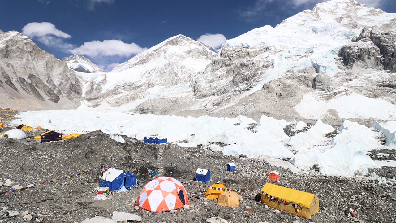
Today is the pinnacle of your Everest Base Camp Gokyo Lakes Trek, both literally and emotionally. The trail leaving Lobuche follows the western edge of Khumbu Glacier, the lifeline of the Everest region. The trail is raw and ancient, it is composed of loose moraines, ice ridgelines and grey glacial outwash.
After about 3 hours of walking, you will arrive at Gorakshep, the final outpost before the base camp. Goraskhep is situated on a sandy glacial basin and is surrounded by towering snow-capped peaks. Standing here feels like you are standing at the edge of the world. In fact, this was once the original Everest Base Camp used in the 1950s expedition.
You will take a short break at Gorakshep to drop your backpack and eat your breakfast. After that, you continue following the trail ahead on the edge of the Khumbu Glacier. The path rises and falls across the unstable moraines, ice fragments and the scattered boulders.
Although the path is not technical, it is slow-going and physically demanding due to high altitude. Moving further ahead on this path of conquest, you traverse across ice cliffs, frozen pools and twisted ridges shaped by the centuries of glacial movement.
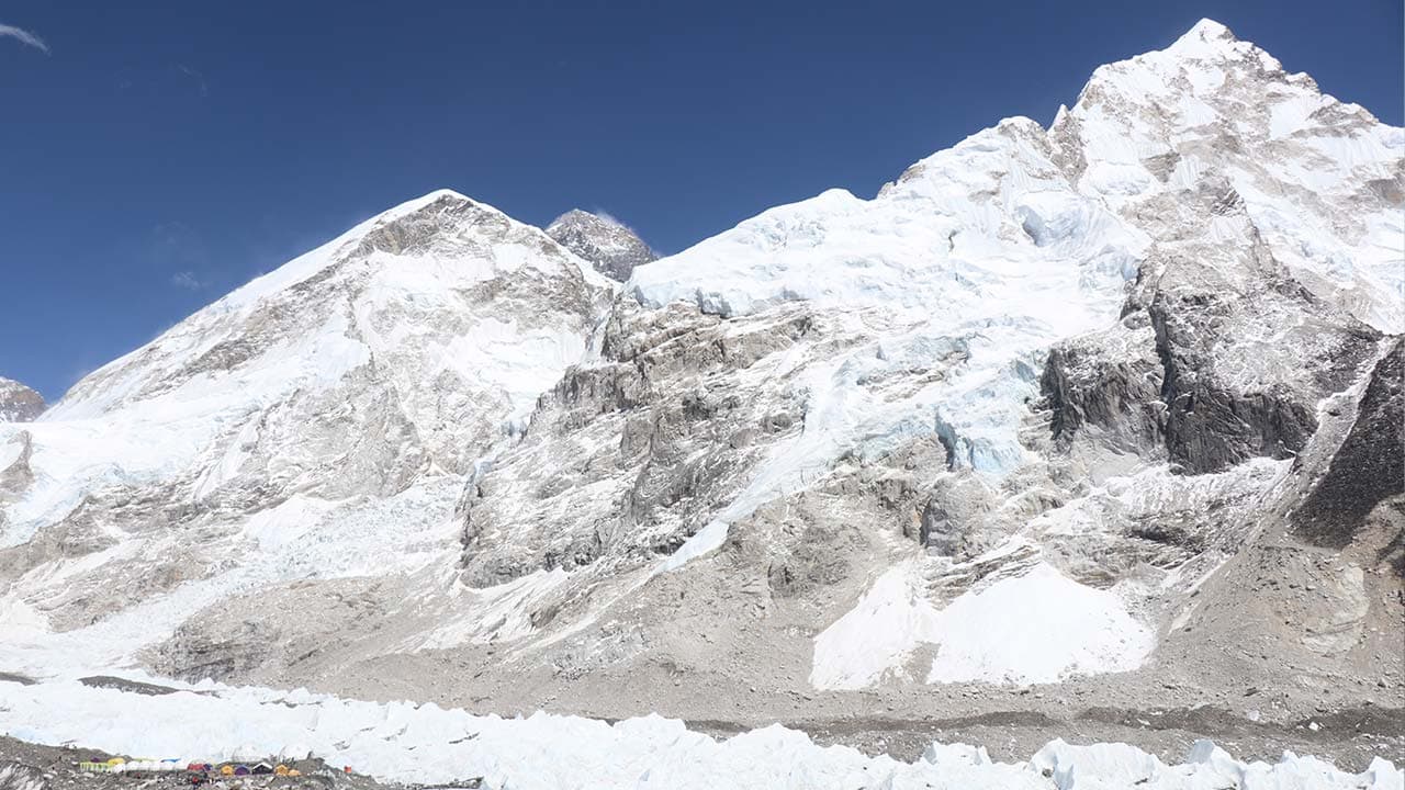
After 2 to 3 hours of trekking, you finally arrive at Everest Base Camp, which is marked by the small rock cairns and the fluttering prayer flags. During the peak climbing seasons, the colorful expedition tents are spread across the rocky expanse, making the base camp feel vibrant and alive.
At the base camp, you stand beneath the mighty Khumbu Icefall. Although the summit of Everest is not visible from the base camp, the surrounding is a pure high-Himalayan drama. You will take your time to soak it all in, take photos and reflect on the achievement. Then, you will return to Gorakshep on the same route for an overnight stay.
Max. Elevation:5364
Duration:8 to 9 hours
Distance:11.5km
Day 11
Morning hike to Kala Patthar (5,550m/ 18,208ft) and trek to Pangboche (3,900m/ 12,795ft): 7 to 8 hours
You will start your adventure before sunrise today to climb Kala Patthar. This is the most famous viewpoint in the Everest region. Though the route is not technical, the climb is steep and taxing due to the altitude, especially in the early morning cold.
But what awaits you at the top is worth every demanding step. From its summit, you can catch the clear and direct views of Mount Everest’s summit. Likewise, peaks like Nuptse, Changtse, Lhotse and Ama Dablam surround you in the southeast and Pumori rises dramatically behind you.
And, far below the winding Khumbu Glacier, it glitters in the morning sun. This is the highest point in your Everest Base Camp with Gokyo Lake Trek and a deeply emotional one too. The trekkers who venture this viewpoint take their time to reflect, photograph, or simply stand in silence, feeling the tranquil Himalayan ambiance.
After descending back to Gorakshep, taking your time to rest and grab your breakfast, the trek heads downhill, which marks the beginning of your return trip. Leaving Gorakshep, you will follow the trail past Lobuche, gradually descending through the rock field and moraines.
Shortly, you arrive at Thukla (Dughla) Village, where the path passes the Everest Memorials, stone chortens built in honor of the fallen climbers on the slope of the tallest peak in the world. From Thukla, the trail splits two ways. You will leave the main EBC highway and move along the lesser-traveled path on the east side of the valley toward Pheriche Village.
From Pheriche, the path drops steeply across the alpine slopes and the dwarf juniper shrubs until re-entering the treeline. After a couple of hours, you will then pass through a small seasonal settlement of Shomare, which is often used as a lunch stop.
Then, in the last stretch, you will follow a gentle descent from Shomare to Pangboche. This is one of the oldest and most culturally significant Sherpa villages in the region. Perched below Ama Dablam’s vast ridgeline, this village is also home to Pangboche Monastery, an ancient monastery believed to be more than 600 years old.
Heli Return Option
For trekkers who want to avoid the long descent after completing the exploration of both major highlights, Gokyo Lakes and Everest Base Camp, the helicopter return from Kala Patthar or Gorakshep is a rewarding option. This return flight will elevate your experience as it not only saves 2 to 3 days of downhill trekking but also offers a stunning aerial perspective of the entire Khumbu.
This heli return option is ideal for those short on time, physically exhausted, or seeking a once-in-a-lifetime luxury ending to this intense high-altitude endeavor. The helicopter flight from Gorakshep to Kathmandu costs about US$ 1,350 to US$ 1,400 per person.
But, this rate is only applicable for the peak trekking seasons (spring and autumn) when there is a large inflow of trekkers in the region. During the off-season trekking points (monsoon and winter), the cost of the flight depends on the number of passengers. If you want to hire a private charter cost is around US$ 5,200 for 2 passengers and US$ 7,200 for a group of 3 to 4 members.
Max. Elevation:3900
Duration:7 to 8 hours
Distance:15.2km
Day 12
Pangboche to Namche Bazaar (3,440m/ 11,286ft): 6 hours
You will begin your trek on this day with a gentle descent from Pangboche. The path is well-trodden and offers stunning morning views of Ama Dablam’s southwest face. As you continue walking downhill, the path weaves across stone walls and scattered chortens before dipping toward the treeline.
Then, you will arrive at Debuche Village, a quiet forest hamlet nestled among the rhododendrons and fir trees. If you want, you can visit Debuche Nunnery here, one of the few active Buddhist nunneries in the Khumbu region. From Debuche, the trail climbs gently to a suspension bridge over Imja Khol and the steady climb ahead takes you to Tengboche Monastery.
This is the largest and most significant monastery in the Everest region, with 360° panoramic mountain views. From here, a long descent through the lush pine and rhododendron woodland will lead the way to Phunki Tenga. In the mainstream Everest Base Camp Trek route, this riverside destination is a popular lunch stop.
After crossing a bridge ahead of Phunki Tenga, it is time to push uphill on switchbacks through the shaded woods to Kyangjuma Village. From here, the trail again descends gently along the panoramic hillside and loops back to the beating heart of Khumbu, Namche Bazaar.
By afternoon, you are back in your teahouse in Namche. After a long mountain journey, the altitude feels comfortable again and the vibe is lively. You have completed the high-altitude phase of your Himalayan adventure. Now, it is time to rest, reflect and maybe treat yourself with a proper cup of coffee or a sweet pastry.
Max. Elevation:3440
Duration:6 hours
Distance:13.8km
Day 13
Trek back to Lukla (2,860m/ 9,383ft): 6 to 7 hours
Leaving the amphitheater of Namche, your journey starts with a steep drop down from the upper ridge toward the Hillary Suspension Bridge below. You make your descent through the thick pine forests before crossing the suspension bridge near Larja Dobhan.
From here, the trail levels out slightly and you will rejoin the main Everest trail and pass through Jorsalle Village. Then, you will exit the Sagarmath National Park and continue walking along the riverbank. From here, the path continues along the pine groves and riverbanks to Monjo Village.
You may stop here for a while for a light snack or tea, soaking in the nostalgia of the familiar chortens, lodges and mani walls. The trail further ahead continues through Benkar and you will cross a few short suspension bridges to reach Phakding Village.
During the final leg, the trail rolls gently alongside the riverbanks and through beautiful settlements like Ghat and Chheplung to reach Lukla. By late afternoon, you will check into your lodge, unwind with your crew and take a well-deserved breath.
Many trekkers celebrate their final night in Lukla with warm Sherpa meals, hot drinks and heartfelt reflections. Tomorrow, you will board a morning mountain flight back to Kathmandu. But tonight, you will rest where it all began.
Max. Elevation:2860
Duration:6 to 7 hours
Distance:17.9km
Day 14
Fly back to Kathmandu (1,400m/ 4,593ft) and a leisure day: 35 minutes
As the morning light gently spills over the Lukla airstrip, you will board a small aircraft that takes you soaring above the Himalayas. The flight is short, but the views are breathtaking. Snow-clad ridges, terraced hillside and deep river valleys unveil in front of you like pages from your journey turning into memory.
Touching down at Kathmandu feels like re-entering the real world after a dream. Warm air, the sound of horns and faint incense drift to welcome you back to the vibrant chaos of the capital. But the memories of the mountain will remain deep in your heart.
The tranquil silence of Gokyo, the thrill of Cho La Pass and the quiet majesty of Everest Base Camp stay engraved in your soul. The rest of the day is yours. You can explore the local cafes and restaurants, visit nearby highlights, or just stroll around the old city streets.
Thank you for choosing Eco Holidays Nepal for your Everest Base Camp Trek via Gokyo Lakes. We hope we will see you again for your next big quest. If you need any post-trek assistance with visa extension, transport arrangements, or airport transfers, feel free to contact us. Have a safe journey!
Max. Elevation:1400
Duration:35 minutes
Distance:138km(flight)
If the provided schedule isn't suitable for you, we can create personalized travel arrangements.
Everest Base Camp Gokyo Lakes Trek Map & Elevation
Loading map...
Altitude Chart
Altitude in:|
Essential Information
Everest Base Camp Trek via Gokyo Lakes Trek Difficulty
The Everest Base Camp Gokyo Lakes Trek is a moderate to challenging high-altitude trek that demands good physical conditioning, mental resilience and careful acclimatization. This iconic Himlayana adventure covers rugged mountain terrains, steep ascent, glacier crossing and a high mountain pass (Cho La Pass- 5,420m/ 17,782ft).
Thus, his trek is more demanding than the classic Everest Base Camp Trek route. But, at the same time, it is also more rewarding for those who are prepared to take it on. During this moderate to challenging level journey, you will trek 5 to 6 hours each day on average.
Likewise, you will consistently stay over the altitude of 4,000 meters (13,123 feet). The climb to Gokyo Ri, crossing Cho La Pass and the final push to Everest Base Camp and Kala Patthar are the most physically demanding sections of this trek.
While no technical climbing skills are essential, a solid trekking background or necessary endurance training beforehand is highly recommended for this journey. One of the biggest challenges of this trek is altitude-related risks.
Even with a well-designed itinerary plan, it is crucial to stay vigilant about the symptoms related to Acute Mountain Sickness (AMS). Similarly, a slow pace, proper hydration and a good level of nutrition play a big role in staying safe during this high-altitude endeavour.
Best Time to Trek
Everest Base Camp with Gokyo Lake Trek route across Cho La Pass is much more remote and demanding than the classic EBC Trek. Thus, your choice of season will significantly affect both your experience and safety. In general, spring (March to May) and autumn (September to November) are considered the two best periods for this trek.
However, it's not like that other seasons don’t bring value to the journey. So, here is a practical breakdown season-by-season, highlights, expected temperatures and which is best suited as per your preference.
Spring (March, April and May)
Spring is one of the two best trekking seasons in Nepal. As the winter season releases its grip, the trails start to clear up, the air gets warmer and the rhododendrons begin to bloom in the lower elevations. The snowpack over Cho La also begins to melt this season, making the high pass more passable.
Trekking in spring is ideal for first-time trekkers with good fitness, those looking for good weather without peak-season crowds, safe crossing of Cho La and photographers who are seeking both alpine and floral landscapes.
Highlights of the Spring Season
Clear skies and excellent visibility
Blooming rhododendrons and other wildflowers at lower elevations
Comfortable daytime and nighttime temperatures
Rare snow-clad scenery is still intact in higher altitudes
Fresh, dust-free trails and snow-fed rivers
High probability of wildlife spotting
Temperatures in Spring Season: 5°C to 15°C (daytime) and -5°C to -12°C (nighttime)
Autumn (September, October and November)
Autumn is the most popular and reliable season for this Himalayan adventure. After the monsoon clears up the dust and pollution from the air, the mountain views are crisp and sharp under the clear blue skies.
The weather is generally stable in this season and the conditions over Cho La Pass and Gokyo Lakes are excellent. As for the nights, they can be colder than in spring, especially at the higher elevations. But, the trade-off is stable weather, safer trails and breathtaking clear vistas.
This season is ideal for trekkers prioritizing stable weather nd views, those who want to cross Cho La Pass with confidence and photographers as well as nature lovers.
Highlights of the Autumn Season
Most monsoon clarity offers the sharpest and most dramatic mountain views
Stable and dry weather, which makes traversing and crossing Cho La Pass safe
Golden alpine landscape in full color
Buzzing trail vibe with global trekkers
Great photo conditions, clear and sharp
Teahouses fully open with the best services
Temperatures in Autumn Season: 5°C to 14°C (daytime) and -12°C to -14°C (nighttime)
Monsoon (June, July and August)
This rainy season brings heavy downpours to the lower valleys and clouds often obscure the mountain views. Monsoon is considered the least favorable season for most trekkers. While trekking in this season, trekkers need to deal with heavy rainfall in the lower region, muddy trails, leeches, flight delays and limited visibility.
Crossing Cho La Pass can also be dangerous during this time due to wet snow and rockfall. However, as the Gokyo region lies partly in the rain shadow zone, with proper gear and flexibility, some experienced trekkers can still take on this route.
Doing the Everest Base Camp and Gokyo Lakes in the monsoon is only suitable for experienced trekkers who can handle unpredictable weather, trekkers who are seeking complete solitude and monsoon photographers seeking moody skies and greenery.
Highlights of the Monsoon Season
Lush and green trail bursting with life
Fewer trekkers and maximum solitude
Warmer days make hiking more comfortable
High-flowing rivers and active waterfalls
Misty skies and dramatic light break through clouds
Local farming scenes along the route
Temperatures in Monsoon Season: 15°C to 22°C (daytime) and 0°C to -5°C (nighttime)
Winter (December, January and February)
Trekking in winter offers solitude and raw beauty, but it comes with harsher conditions. The trekking trail becomes much quieter and the landscape transforms into a frozen wilderness. However, Cho La Pass is often closed due to heavy snow and ice.
Temperatures of the region also drop well below the freezing point. Only well-prepared and seasoned trekkers with proper winter gear should consider this season. Even then, weather windows can be unpredictable, which makes the navigation risky.
So, if you experience and cold-tolerant trekkers with winter trekking gear, seeking solitude and raw beauty and won’t mind skipping Cho La Pass and confusing on Gokyo or EBC separately, winter trek is still a possibility.
Highlights of the Winter Season
Snow-covered peaks and frozen lakes
Peaceful and empty trail with rewarding silence
Clear skies and a magical sunrise view
Excellent night skies for stargazing
Strong sense of wilderness and isolation
Temperatures in Winter Seasons: 12°C to -5°C (daytime) and -5°C to -22°C (nighttime)
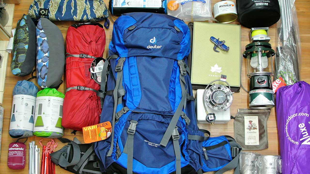
Packing List
Doing the Everest Base Camp Gokyo Lakes Trek is not an average hike. It is a high-altitude endeavour that tests your endurance across the glaciers, passes and the Himalayan valley. Packing for this trek is not just about comfort, it is about safety, managing risks and staying mentally sharp day after day.
Here is a detailed breakdown of what you will actually need for the trek with no fluff, no excessive and focus on just reliable layers and gear.
Clothing and Layering
Base layer
Insulated fleece or lightweight jacket
Waterproof and windproof outer shell jacket
A heavy down jacket for cold nights
Lightweight and thermal trekking pants
Waterproof overpants
T-shirt
Gloves
Undergarments
Footwear
Trekking boots
Camp shoes or sandals
Lightweight and wool or insulated socks
Gaiters
Personal Care
Toothbrush and toothpaste
Face wipes
Tissue roll or toilet paper
Hand sanitizer
Quick-dry towel
Lip balm and sunscreen with SPF
Biodegradable soap
Feminine hygiene products
Nail clippers and a small mirror
Earplugs
Deodrant
Trekking Gear
Backpack
Duffel bag
Trekking poles
Headlamp
Sunglasses
Water bottles
Thermos flask
Dry bag or stuff sacks
Packing cubes
Shoes bags
Power bank
Universal adapter
Accommodation and Food During Trek
On the Everest Base Camp Trek via Gokyo Lakes, you will be staying in basic teahouses that are often family-run. Although they are standard, these teahouses offer warm meals, basic lodging and a communal atmosphere. These passes are scattered throughout the major villages and remote passes. So, you will never be without shelter.
Most rooms in such a teahouse have simple twin-bed setups with wooden walls, thin mattresses, pillows and plenty of blankets. Heating is only available in the dining hall, where trekkers gather around the central stove in the evenings. Toilets along the teahouses range from western-style flush units at the lower trail to squat toilets at higher altitudes.
Food on Trek: What You Will Eat
Food on this iconic trail of Everest Base Camp with Gokyo Lake Trek is filling, repetitive and car-heavy, which fuels your body for the long walking days. Teahouses along the trail offer a similar type of menu with a mix of Nepali, Tibetan, Indian and simple Western dishes.
Here is what you can expect during breakfast, lunch and dinner on trek:
Breakfast Menu
Tibetan bread with jam or honey
Pancakes
Oatmeal
Porridge
Eggs
Toast
Chapati
Museli
Tea (black, lemon, ginger, mint)
Lunch and Dinner Menu
Dal bhat
Fried rice
Sherpa stew
Chowmein
Spaghetti
Spring rolls
Thukpa
Garlic soup
Fried potatoes
Vegetable curry
Momo
Drinking Water
Staying hydrated on a high-altitude journey such as Everest Base Camp via Gokyo Ri is non-negotiable. As you gain altitude, the dry air, increased breathing rate and long trekking hours cause your body to lose fluids faster than usual. That’s why it is crucial to drink at least 3 to 4 liters of water daily. More on days when you are crossing high passes like Cho La or hiking to Kala Patthar.
Drinking water is available in teahouses and villages along the trail. There are taps, refill stations, boiled water and bottled water options. Boiled water is the safest bet during a remote Himalayan journey. You can also drink from the clean stations suggested by guides. But it is essential to treat the water before you drink it.
Training and Preparation Tips
Exploring Everest Base Camp and Gokyo Lakes means taking on a multi-day high-altitude challenge that demands solid physical preparation and mental stamina. You will spend multiple days above 4,000 meters, cross glaciers and the demanding Cho La Pass. Thus, it is necessary to condition your body for long, steady climbs and steep descents.
You should begin your training 8 to 10 weeks in advance for this high-altitude trek. Focus on your endurance level, with emphasis on stair climbing and back-to-back long walks with a weighted backpack, stimulating the real trail conditions.
Cardiovascular fitness also plays a huge role in how well you can handle altitude. Strengthen your legs and core to stay stable on uneven trails. Similarly, you shouldn’t underestimate the mental game of the trek as you will trek through isolation, demanding routes and physical exhaustion.
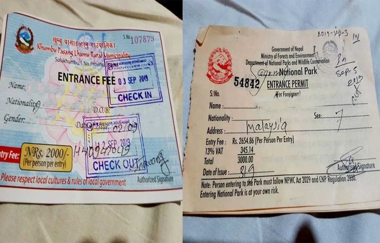
Permits and Regulations
To trek in the Everest region, you will need the right permits to legally access Sagarmatha National Park and local checkpoints along the way. The Everest Base Camp and Gokyo Lakes Trek map passes through protected conservation areas and Khumbu municipalities. So, make sure you have these two essential documents before heading into the mountains.
Permits Necessary for Everest Base Camp Gokyo Lakes Trek
Khumbu Pasang Lhamu Rural Municipality Permit
Sagarmatha National Park Entry Permit
You do not TIMS Card to trek in the Everest region as the local permit works on its behalf. Make sure to carry physical copies of both permits at all times. If you are trekking through an agency like Eco Holidays Nepal, they will arrange these permits for you.
Is This Trek Suitable for Beginners?
The Everest Base Camp Gokyo Lakes Trek difficulty is at a moderate to challenging level. So, it is not an entry-level trek, but still, it is not completely off the table for beginners. The high altitude nature of the trek, remoteness and crossing a major Himalayan pass make this trek more demanding.
That said, if you are a first-time trekker with a solid level of preparation, decent fitness and the right mindset, this trek is absolutely achievable. You don’t need technical climbing skills or prior high-altitude experience to do this trek. But, you do need to be consistent for 2 to 3 months to do this trek and understand the basis of altitude acclimatization.
Doing a guided group trek also helps first-time trekkers to manage logistics, pace and emergency situations. So, to summarize, yes beginners can do this trek, but it is not for the untrained or the unprepared.
Trek Cost
The standard Everest Base Camp with Gokyo Lake Trek cost margin is around US$ 1,500 to US$ 2,000 per person. As this itinerary plan covers two major destinations in the Everest region, it is slightly expensive than a single highlight exploration itinerary. The overall cost varies depending on how you organize it.
This cost range of the standard package generally covers domestic flights, permits, guides, accommodation and meals. The domestic flight alone can cost up to U$ 400 for a two-way flight. If you are buying a package for this trek, they will handle all the logistics, making the trek smoother and safer.
Travel Visa
Getting a travel visa in Nepal is easy and straightforward for most nationalities. You can either apply online or through the eVisa system before your trip or get a visa on arrival at Tribhuvan International Airport, Kathmandu. The process is simple: just fill out a form, bring a passport-sized photograph and pay the visa fee in cash.
Visa fees depend on the length of your stay. You can get three types of visas for your stay in Nepal:
15 Days Visa— US$ 30
30 Days Visa— US$ 50
90 Days Visa— US$ 125
As the Everest Base Camp via Gokyo Ri takes nearly two weeks, it is safest to get a 30-day visa if you are planning to stay a little longer. In case if you have to extend your visa, then you will need to buy a minimum of 15 15-day extension, which will cost US$ 45.
**Note: Your passport must be valid for at least 6 months from your arrival date. And, you will need to carry a printed or digital copy of your visa approval if you have filled the online form**
Everest Base Camp Gokyo Lakes Trek FAQs
Trekking Faqs
How do I prepare for the trek?
As we all know the mountains are in high altitude region, we need to walk a long way without any means of transpotation, so to hike a long way we need to be fit by work out daily. And the pace of the speed must be normal so that there wont be any issue on breathing. Understanding the environment and trail of the trip may help your trip more comfortabe and adventurous.
Why is Acclimatization necessary?
Acclimatization is essential for the trek to avoid altitude sickness. Although the trek is ideal you must ensure that the acclimatization is appropriately performed. As the mountains are in high altitude, we human living on low altitude cant adopt easily into high level altitude. There are other factor, hydrating regularly along the trail. You should also avoid caffeinated drinks and alcoholic beverages. As you can have DIAMOX tablets which reduce the altitude sickness, you can ask for this tablet before the trek starts or in the middle of the trek, as you feel you might need those tablet for your further trail, with your guide. And this tablet ensure that you will not have a altitude sickness.
Why Choose Everest Region for Trek?
The Everest Region gets known for its incredible natural terrain and scenic landmarks. You must cross beautiful Himalayan foothills to arrive at the highest mountain Base Camp. You will pass through some of the best trekking paths in the world.
The foothills of Mt Everest (8848.86m) are quite an adventure for anyone making this journey. The remote rural settlements offer you the best of adventure in all its glory. The region has numerous scenic natural attractions, including waterfalls, hills, forests, rivers, etc.
Moreover, you can also get to explore the cultural aspects during the trek. You will pass through the ancient Sherpa settlements during the Everest Base Camp Trek with Helicopter return. You will learn about the region’s culture, traditions, and heritage with the help of your professional guide during this trek. Therefore, to experience these, you should trek in the Everest region.
What are the accommodation facilities on the trek?
Trekking routes throughout Nepal are supported by a wide network of teahouses and lodges that offer accommodation to trekkers. These establishments typically provide basic but comfortable rooms, usually with twin beds and shared bathroom facilities. In addition to lodging, many teahouses also offer meals and a communal dining area where trekkers can relax and socialize. Depending on the location and altitude, some teahouses may also provide extra amenities such as hot water showers, charging options, and limited internet access. Overall, they contribute to a convenient and culturally immersive trekking experience across the country.
What are the food facilities on the trek?
Food in the trek is the Nepalese diet of “Dal Bhaat.” You can have various other food items like noodles, chapati, thukpa, etc. Hot drinks like tea, garlic soup, coffee, etc., are popular in cold, high-altitude regions. Besides that, you can also carry your snacks to eat while trekking.
What are drinking water facilities on the trek?
You can get water facilities at the tea houses, or you can use water purification tablets on tap water. Bottled water is also valuable in the teahouses.
Why trek with Eco holiday Nepal?
Trekking with Eco Holidays Nepal is like walking through a dream with friends who truly care. We don't just guide you through breathtaking landscapes but also share beautiful memories and the heart of Nepal with you. With our warm hospitality, deep local knowledge, and genuine commitment to protecting nature and supporting all the local communities, every step you and we take becomes a beautiful memory that we will cherish forever.
Yes, Eco Holidays Nepal provides clients with porters as part of a trekking package, porters will carry your main luggage, allowing you to enjoy your trek with just a light daypack. Also, Eco Holidays Nepal will provide you with a professional and licensed trekking guide, Your guide will lead the way to ensure your safety and will share local insights and make your journey meaningful with stories and cultural knowledge.
Please note that porter service may or may not be included in your selected package. If porter service is included, the cost will be covered in the package price. If the package does not include porter service, clients can request it separately, and the cost will need to be paid by the clients themselves. We’ll be happy to assist with porter arrangements based on your needs.
FAQs
How difficult is the Gokyo Lakes Trek?
Gokyo Lakes Trek is a moderate-level of trekking journey. The long walking hours, the high-altitude nature of the trek and isolation factors contribute to the difficulty level of the trek. If you combine Everest Base Camp and Gokyo Lakes, it can turn into a moderate to challenging level of endeavor due to the involvement of Cho La Pass (5,420m/ 17,782ft).
Can a beginner do Everest Base Camp and Gokyo Lakes?
Yes, a well-prepared and determined beginner can absolutely complete this trek. However, this isn’t the easiest introduction to high-altitude trekking. So, beginners need to seriously commit to physical training, understand the risk of altitude and follow a gradual itinerary.
Is this trek worth it?
The Everest Base Camp Gokyo Lakes Trek is 100% worth it. This combined route is often considered the most scenic way to reach the Everest Base Camp. It combines the best of both worlds, the raw grandeur of Gokyo Valley and the iconic EBC experience.
How many days is Gokyo Lakes and Everest Base Camp itinerary?
The standard Gokyo Lakes and Everest Base Camp itinerary duration is 14 to 16 days. However, the overall length depends on the pace, acclimatization schedules and side-trips around the region.
How much does Everest Base Camp Trek via Gokyo Lakes Trek cost?
For a standard package, the EBC and Gokyo Lakes Trek cost is approximately US$ 1,500 to US$ 2,000 per person. A standard trip package covers expenses for domestic flights, permits, accommodation, meals, a guide and logistics. If you opt for helicopter return or luxury lodge trekking, the package can be more costly.
Do I need to cross Cho La Pass on this route?
Yes, this classic route connects the Gokyo Valley to Everest Base Camp via Cho La Pass. It is one of the highest and most demanding sections of the trek.
Are there teahouses available along the Gokyo route and Cho La Pass?
Most definitely, the entire Gokyo and Everest route is well-established with teahouses in every major village along the way. However, at the remote and high-altitude part of the mountain, the available services can be basic and limited.
Is there internet or WiFi access during the trek?
Many teahouses en route this duo highlight exploration offer paid WiFi access through systems like Everest Link. However, the services may not always be reliable and can be limited.
Are there any risk of altitude sickness on Everest Base Camp and Gokyo Lakes route?
As some of the major elevation points of the trek, Everest Base Camp, Gokyo Ri, Cho La Pass and Goraksehp rise above 5,000 meters, the risk of altitude sickness is real in this trek. However, with proper acclimatization, slow pace, sufficient hydration and a well-balanced meal, the risk of you catching AMS decreases drastically.
Is travel insurance required for this trek?
Travel insurance is absolutely necessary for high-altitude treks in Nepal. For the Everest Base Camp with Gokyo Lake Trek, it's best if you get insurance that covers up to 6,000 meters and includes emergency helicopter evacuation.
Do I need to carry cash, or are there ATMs along the trail?
Once you leave Kathmandu or Namche Bazaar, there are no functioning ATMs on the trail. So, you must carry enough Nepalese rupees in cash for the entire trek.
It wasn't just a trek; it was finding peace in nature. The welcome in the jungle with the sound of prayer flags and the wind flowing was amazing. The itinerary planned by Eco Holidays Nepal was excellent. Being in the base camp surprised me with the nature, and the atmosphere was amazingly beautiful. This was out of the world.
The amazing Gokyo Lake in the middle of the mountain was another beautiful place for relaxation. I recommend everyone take this trail.
CChirtopher5th Jan, 2025
Second time in Nepal
It was my second time in Everest Base Camp, but the first time in Gokyo Lake. The lake in the middle of the mountain was crazy, as the season was winter; the lake was fully covered by ice. The weather was extremely cold and freezing, but the image that I captured on the lake was extremely wonderful.
The guides were so friendly and cooperative that they made my trip enjoyable. And further, I could again join Eco Holidays Nepal for another thrill and experience in the coming years.
JJohn Peter1st Nov, 2022
Beautiful Lake in Himalaya
It was amazingly beautiful; the glacier and the landscape on the way were stunning. The Gokyo Lake in the middle of the mountain was magnificent. It was my great experience in the mountain for the first time in Nepal. The guides were so supportive, with their guidance and information making my trip great. For the first time I was aware of the culture and tradition on the mountains.
Thank you so much, Eco Holidays Nepal, for making my trip awesome, and the services provided by them were really incredible.