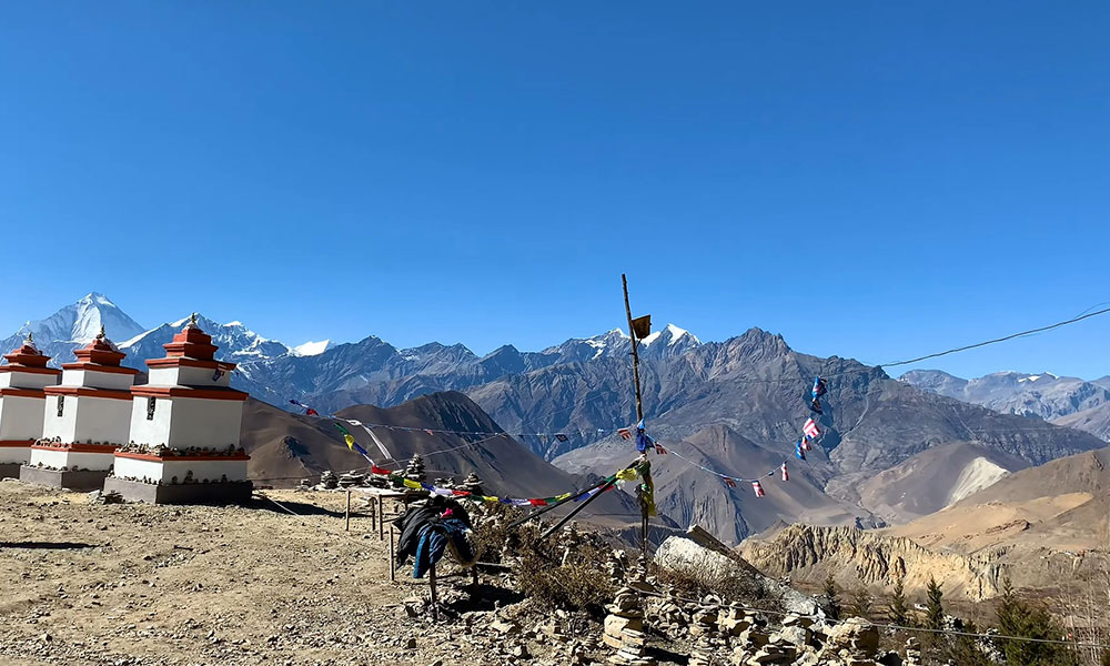
Highlights of Jomsom Muktinath Photography Tour 8 days
Explore five UNESCO World Heritage Sites in Kathmandu Valley: Kathmandu Durbar Square, Swayambhunath, Pashupatinath, Boudhanath and Patan Durbar Square
Photography-focused journey from Kathmandu to Mustang and Muktinath, covering the changing landscapes of Nepal from the historic Kathmandu Valley and green middle hills to the dry, high-altitude terrain of the Kali Gandaki Valley
Visit Manakamana Temple and photograph the Trishuli River corridor, including hill landscapes, riverside settlements, suspension bridges, terraced farmland and changing scenery along the Kathmandu to Pokhara route
Photograph Phewa Lake in Pokhara, including traditional boats, lakeside activity, reflections and, in clear weather, Machhapuchhre and the Annapurna range across the water
Travel through the Kali Gandaki Valley to Mustang, passing Beni, Tatopani, Ghasa, Marpha and Jomsom as the landscape changes from lush river valleys to the dramatic rain-shadow environment of Mustang
Spend an evening photographing historic Kagbeni, including its narrow lanes, mud-brick houses, traditional courtyards, prayer wheels, chortens, monastery and barren mountain surroundings
Visit Muktinath Temple at 3,710 mters (12,172 feet), one of Nepal's most important Hindu and Buddhist pilgrimage sites
Photograph Dumba Lake and Thini Village, capturing the contrast between the high-altitude lake and Mustang's barren terrain, along with traditional stone houses, agricultural terraces, village paths and local mountain life
Visit Rupse Waterfall on the return journey, combining the waterfall with the rocky landscape and Kali Gandaki River
Relax at the natural hot springs of Tatopani, adding a slower cultural and landscape experience to the otherwise photography-intensive mountain journey
Explore Pokhara's Mountain Museum, Gupteshwor Cave, World Peace Pagoda and Pumdikot, including the evening aarti at Pumdikot and photography opportunities overlooking Pokhara Valley and Phewa Lake
Capture sunrise from Sarangkot, with early-morning views toward Machhapuchhre, Annapurna and Dhaulagiri and changing light across Pokhara Valley
Photograph Bandipur on the return journey to Kathmandu, with time to explore its preserved Newari houses, brick-and-timber architecture, temples, courtyards and historic streets before continuing to Kathmandu
Travel entirely by private vehicle, allowing the photography schedule to remain flexible for viewpoints, villages, roadside landscapes, rivers, waterfalls and changing light conditions rather than following a rigid group-tour transfer
Trip Overview
The Muktinath Photography Tour 8 Days is built around one of the most interesting contrasts in Nepal: sacred Himalayan landscapes, traditional mountain communities, and the stark, dry terrain of Mustang coming together in a relatively short journey. Muktinath itself sits at 3,710 meters and is one of Nepal’s most important pilgrimage sites for both Hindus and Buddhists, but the photographic appeal extends well beyond the temple. The surrounding landscape, villages, architecture, religious practices, and changing light give the destination a character that is difficult to capture on a conventional sightseeing tour.
What makes this photography trip particularly rewarding is the range of subjects in a single journey. You can move from the carved temples, stupas, courtyards, and street life of the Kathmandu Valley to the lakeside landscapes of Pokhara and then into the distinctive architecture and arid mountain scenery of Mustang. Places such as Marpha, Kagbeni, Thini Village, Dumba Lake, and Muktinath offer very different visual environments, while Sarangkot, Bandipur, Rupse Waterfall, and the Kali Gandaki landscapes add further variety.
There is also a strong human and cultural dimension to the experience. Pilgrims, monks, traditional villages, prayer wheels, monasteries, local markets, old stone and mud-brick houses, courtyards, and everyday mountain life provide opportunities for documentary and cultural photography alongside landscapes and architecture. With private transportation and a flexible pace, the tour is designed to give you time to stop, observe, and photograph rather than simply pass through each destination.
You do not need to be a professional photographer or a technical trekker to join the Muktinath Photography Tour Nepal. The journey involves no demanding or technical trekking, and its highest point is reached by vehicle. Thus, it is an accessible way to explore and photograph the Himalayan environment while still reaching one of Nepal’s most distinctive high-altitude destinations.
Why Choose Jomsom Muktinath Photography Tour?
This 8-day itinerary is designed to combine Nepal’s cultural heritage, Himalayan landscapes, village life, and pilgrimage sites without turning the trip into a rushed point-to-point transfer. The route gradually moves from Kathmandu’s historic core through Pokhara and the Kali Gandaki corridor to Kagbeni and Muktinath at 3,710 meters, then returns through Tatopani and Pokhara.
Strong Photographic Variety: Five major heritage sites in Kathmandu, Phewa Lake, Marpha, Kagbeni, Muktinath, Thini Village, Dumba Lake, Rupse Waterfall, Sarangkot, Bandipur, and the surrounding Himalayan landscapes provide very different subjects within one trip.
A Complete Kathmandu to Mustang to Pokhara Circuit: The itinerary covers the major photographic environments rather than focusing only on Muktinath, including the transition from green middle hills to the dry landscapes of Mustang.
Photography-Friendly Transportation: Private vehicles allow flexible stops along the route for landscapes, villages, architecture, rivers, waterfalls, and local life instead of following a rigid group schedule.
Cultural Depth Beyond Landscapes: Kathmandu’s UNESCO heritage sites, Marpha and Kagbeni’s traditional architecture, Muktinath’s Hindu and Buddhist traditions, and Bandipur’s Newari townscape add substantial cultural subjects to the trip.
Accessible Without Technical Trekking: The highest point is 3,710 meters at Muktinath, but the journey is primarily vehicle-based with short walks and photography sessions, making it suitable for photographers who want Himalayan scenery without a demanding trek.
Balanced Photography and Travel Experience: Sunrise at Sarangkot, an hour of boating on Phewa Lake, Muktinath pilgrimage, Tatopani hot spring, and village exploration keep the itinerary varied rather than making every day solely about photography.
Gradual Altitude Progression: The route moves from Kathmandu at around 1,400 meters to Pokhara, Kagbeni at 2,840 meters, and Muktinath at 3,710 meters, allowing the journey to gain altitude progressively rather than reaching the highest point immediately.
A Route Shaped by the Kali Gandaki: The journey through Beni, Tatopani, Ghasa, Marpha, Jomsom, and Kagbeni adds rivers, waterfalls, traditional settlements, apple orchards, and changing Himalayan terrain to the photographic experience.
Flexible Across Different Seasons: Muktinath and Mustang lie in the rain shadow of the Annapurna and Dhaulagiri ranges, making the region comparatively drier during the monsoon, while spring and autumn offer the most favorable overall conditions for clear mountain photography.
Photography Combined With Local Experiences: The itinerary includes opportunities to observe pilgrimage, village life, traditional architecture, local markets, religious sites, and everyday activity, giving photographers subjects that extend beyond conventional mountain landscapes.
Cost Details
What's Included in Jomsom Muktinath Photography Tour 8 days
Airport pick up and drop by private vehicle.
Kathmandu – Pokhara by flight.
Pokhara-Kathmandu tourist bus.
Pokhara-Jomsom-Pokhara round fly.
Three meals during Mountains area.(Breakfast,Lunch and Dinner)
A professional guide during tour.
All necessary permit and TIMS card.
Tea house accommodation during tour in Mountain.
Two night 3 star standard hotel in Pokhara .
Phewa lake Photography.
Route map.
All necessary vehicles during tour.
Fare well dinner with culture show.
What's Excluded in Jomsom Muktinath Photography Tour 8 days
Extra night Hotel in Kathmandu and Pokhara.
All drinks during Tour in Mountain.
Private vehicle or fly ticket Pokhara to Kathmandu.
Extra charge which is not cover in Package.
All entry fees if required.
Extra activities in Kathmandu and other parts of Nepal.
Price & Availability
Itinerary of Jomsom Muktinath Photography Tour 8 days - 8 days
Day 01
Arrival in Nepal, Transfer to Thamel and Evening Walk Around Thamel and Old Market. Stay in a 3 Star Hotel With Breakfast.
Your Muktinath Photography Tour begins with your arrival in Kathmandu. After completing the airport formalities, you will be met by our representative and transferred by private vehicle to your hotel in Thamel. After checking in and taking some time to rest, the afternoon or early evening is kept relatively relaxed. This gives you an opportunity to adjust to Kathmandu while beginning your photography experience without a demanding schedule.
As the day cools, we will head out for an evening photography walk through Thamel and the nearby old market areas. Thamel offers a very different visual character from the mountain landscapes that will come later in the tour. Narrow streets, traditional shopfronts, prayer flags, local cafés, courtyards, temples, rickshaws, street vendors, and the changing light of the evening provide plenty of opportunities for candid street and architectural photography.
This walk can also extend toward parts of Kathmandu’s historic old market, where traditional buildings and everyday local activity create a more authentic urban setting. Since this is an introductory evening rather than a fixed photographic session, the pace can remain flexible according to the available light and your interests. You will spend the night at a 3-star hotel in Kathmandu, with breakfast included.
Max. Elevation:1400
Duration:30 Minutes
Distance:200km
Day 02
Full-day Kathmandu Photography Tour (5 Heritage Sites) With Guide. Stay in Kathmandu in Same Hotel With Breakfast.
Day two of this Muktinath Photography Trip is dedicated entirely to Kathmandu’s cultural landscape, taking you to five major heritage sites with a guide who can provide historical and cultural context while allowing enough time for photography. The day begins after breakfast at the hotel. Rather than trying to rush through Kathmandu’s monuments, the tour is arranged to give you opportunities to photograph different architectural styles, religious traditions, streetscapes, and local life across the valley.
The photography route includes Kathmandu Durbar Square, Swayambhunath, Boudhanath, Pashupatinath, and Patan Durbar Square. Together, these sites reveal the extraordinary cultural diversity of the Kathmandu Valley, where Hindu and Buddhist traditions, centuries-old Newari architecture, and contemporary daily life exist side by side. Because this is a full-day photography tour, the exact time spent at each location can be adjusted according to lighting, crowd conditions, and your photographic interests.
A guide accompanies you throughout the day, helping with navigation and providing cultural background while leaving room for photography. After completing the circuit, you return to the same 3-star hotel in Kathmandu for the night.
Max. Elevation:1400
Duration:6 to 7 Hours
Day 03
Drive to Pokhara by Private Car Visiting Manakamana and Trishuli River, Check-in at Hotel, Evening Walk and Photos Shoot Around Lake. Stay in 3 Star With Breakfast.
After breakfast, your photography journey continues west from Kathmandu toward Pokhara, following one of Nepal’s most scenic road corridors. The drive covers approximately 200 km (124 miles) and generally takes 6 to 8 hours, excluding photography and sightseeing stops. Rather than treating the journey as a straightforward transfer, the route is planned around several notable landscapes, towns, rivers, and cultural landmarks along the way.
Leaving Kathmandu, the road climbs gradually through the hills toward Naubise, an important highway junction connecting Kathmandu with Nepal’s central and western districts. From here, the landscape opens into the winding hill country of central Nepal, with roadside settlements, terraced farmland, forested slopes, and distant ridgelines providing changing subjects for photography. The road then descends toward Malekhu, a well-known settlement along the Prithvi Highway where the landscape begins to take on a distinctly river-valley character.
Continuing west, the route follows the Trishuli River, one of the major rivers of central Nepal. A major stop along the journey is Kurintar, located near the confluence of the Trishuli and Marshyangdi river systems. From here, you can reach Manakamana Temple, one of Nepal’s most important pilgrimage sites, by cable car. The temple sits at approximately 1,300 meters (4,265 feet) and provides both cultural and landscape photography opportunities. The hilltop setting, traditional temple architecture, pilgrims, surrounding villages, and expansive views across the central Nepal hills make Manakamana a worthwhile photographic stop rather than simply another sightseeing landmark.
After visiting Manakamana, the journey continues through Mugling, one of the country's major highway junctions. From Mugling, the road follows the Marshyangdi River corridor toward Damauli. These sections of the journey offer a different visual character from the Kathmandu Valley, allowing you to capture everyday life and rural landscapes along the highway. From Damauli, the road continues toward Pokhara, with the surrounding hills becoming broader as you approach the Pokhara Valley.
After arriving in Pokhara, you check into your 3-star hotel and have time to rest before heading out for an evening photography walk around Phewa Lake and Lakeside. The lakefront provides a completely different setting from the day's road journey, with traditional boats, reflections on the water, lakeside cafés, local activity, and the surrounding hills becoming especially atmospheric toward sunset.
Max. Elevation:822
Duration:6 to 8 Hours
Distance:200 KM
Day 04
Drive to Kagbeni via Kalika Temple, Hot Spring, Marpha, Jomsom, Evening Visit to Kagbeni, the Main Gateway of Upper Mustang. Stay in a Nice Tea House With Breakfast.
On day 4 of your Muktinath Photography Tour from Kathmandu, the journey leaves Pokhara and heads north toward the Kali Gandaki Valley, entering the landscapes of the Annapurna and Mustang regions. The route gradually changes from the greener middle hills around Pokhara to the much drier and more dramatic terrain of the Mustang district.
The first part of the drive follows the Pokhara to Beni road, passing through settlements and agricultural hills before reaching Beni, an important gateway to the Kali Gandaki Valley.
From Beni, the road follows the river north through increasingly rugged mountain scenery toward Tatopani. The area is famous for its natural hot springs, making it a worthwhile stop both for relaxation and photography. Continuing north, the road enters the Ghasa area, where the Kali Gandaki corridor becomes narrower and the surrounding cliffs rise dramatically on both sides. The landscape then begins to change noticeably as you approach Marpha, one of the most picturesque settlements in the Mustang region.
Marpha is known for its traditional whitewashed stone-and-mud houses, narrow paved lanes, apple orchards, and distinctive mountain village architecture. The village provides excellent opportunities for photographing traditional Mustang life and architecture. From Marpha, the road continues toward Jomsom, the administrative center of Mustang District, situated at approximately 2,720 meters (8,924 feet). Jomsom lies along the Kali Gandaki River and is surrounded by the barren, wind-carved mountains characteristic of the rain-shadow landscape of Mustang.
After reaching Jomsom, the journey continues north toward Kagbeni, approximately 2,840 meters (9,318 feet) above sea level. Kagbeni is one of the most historically significant villages in the Kali Gandaki Valley and is widely regarded as the gateway to Upper Mustang. Its location at the junction of the Kali Gandaki corridor and the trail toward Upper Mustang gives the village a distinctive cultural and geographical character.
In the evening, we take time to explore Kagbeni on foot. Its narrow lanes, centuries-old mud-brick houses, traditional courtyards, prayer wheels, chortens, monasteries, and views toward the barren Mustang landscape offer some of the most atmospheric photography of the tour. You will spend the night in a comfortable local tea house in Kagbeni, with breakfast included.
Max. Elevation:2804
Duration:7 to 8 Hours
Distance:159 KM
Day 05
Drive to Muktinath Early After Puja (Worship), Drive to Dumba Lake and Thini Village. After Lunch, Drive to Jomsom via Rupse Waterfall.
Your day begins early with a drive from Kagbeni to Muktinath, allowing you to experience one of the most important pilgrimage destinations in the Himalayas before the area becomes busier. Muktinath is situated at approximately 3,710 meters (12,172 feet) and is sacred to both Hindus and Buddhists, making it one of the most culturally significant locations in the Mustang region. After reaching Muktinath, you will have time for puja (worship) and to explore the temple complex.
The site is known for its Muktinath Temple, 108 water spouts, natural flame, Buddhist shrines, and surrounding Himalayan landscape. The combination of religious activity and high-altitude scenery creates a particularly meaningful photographic setting, although photography around active worship should always be approached respectfully.
After the visit, the journey returns toward the Jomsom area. Rather than heading directly back, we take a detour toward Dumba Lake, a small high-altitude lake surrounded by the stark mountain terrain of Mustang. The lake's relatively calm water can create beautiful reflections when the wind is light, while the surrounding dry slopes provide a strong contrast to the blue-green water.
From Dumba Lake, the route continues toward Thini Village, one of the traditional settlements near Jomsom. Thini is known for its stone houses, agricultural terraces, narrow village paths, and views toward the surrounding Himalayan peaks. Walking through the settlement provides opportunities to photograph traditional architecture and everyday mountain life away from the main tourist route.
After exploring Thini, we return to Jomsom for lunch. Jomsom is a natural base for exploring this section of the Kali Gandaki Valley, and a midday break also allows some flexibility before continuing the afternoon journey. After lunch, the drive heads south along the Kali Gandaki corridor toward Rupse Waterfall, one of the most striking natural landmarks along this route. The waterfall drops dramatically through the rocky landscape beside the road, making it an easy and rewarding photography stop.
From Rupse Waterfall, the journey continues toward the Tatopani hot spring area. After arrival, you can relax and take a bath in the natural hot spring, which provides a welcome break after the day's road journey and sightseeing. After the hot spring visit, check into a comfortable local tea house for the night, with breakfast included.
Max. Elevation:2710
Duration:5 to 6 Hours
Distance:24 KM
Day 06
Drive to Pokhara and Sightseeing Tour, Visit Mountain Museum, Gupteshwor Cave, World Peace Stupa and Pumdikot Evening Aarti, Photoshoot in Phewa Lake. Stay in a 3 Star Hotel.
Your journey begins with a drive back toward Pokhara, following the Kali Gandaki corridor through the dramatic transition from Mustang's high-altitude, arid landscape to the greener middle hills of western Nepal. The road passes again through Tatopani, Ghasa and Beni, following the Kali Gandaki River before continuing toward the Pokhara Valley. This return journey itself offers another opportunity to photograph the changing landscape: barren mountain slopes gradually give way to forests, terraced farmland, waterfalls, riverside settlements, and greener hills.
After reaching Pokhara and refreshing at the hotel, the afternoon is dedicated to several of the city's major cultural and natural attractions. The first stop is the International Mountain Museum, where you can learn about Nepal's Himalayan geography, mountaineering history, expedition equipment, mountain communities, and the world's major mountain ranges. For a photography-focused journey, the museum also provides useful context for understanding the landscapes and cultures encountered during the previous days.
From the museum, the tour continues to Gupteshwor Mahadev Cave, located near the famous Devi's Fall area. The cave extends beneath the limestone landscape and is associated with the Hindu deity Shiva. Its interior offers a very different photographic environment, with rock formations, narrow passages, and naturally occurring textures contrasting with the open mountain landscapes seen earlier in the journey.
The route then climbs toward the hilltop World Peace Pagoda, overlooking Phewa Lake and the Pokhara Valley. At approximately 1,100 meters, the viewpoint provides broad views across the lake, surrounding hills, and, when visibility is clear, the Annapurna range and Machhapuchhre (Fishtail). From there, continue to Pumdikot, another prominent hilltop viewpoint south of Pokhara. The large Shiva statue and elevated position provide a distinctive foreground for photography, while the viewpoint opens toward Pokhara Valley and the surrounding mountain landscape.
As evening approaches, return toward the lakeside area for an evening photoshoot around Phewa Lake. The lake is particularly atmospheric around sunset, when boats, reflections, shoreline activity, and the surrounding hills create layered compositions. If the weather is clear, the changing light over Machhapuchhre and the Annapurna range can provide some of the strongest landscape photography opportunities of the entire tour. You will then return to your 3-star hotel in Pokhara for the night.
Max. Elevation:822
Duration:6 to 8 Hours
Distance:153 KM
Day 07
Sunrise Trip to Sarangkot, After Breakfast Visit Lake, 1 Hour Boating and Little Shopping, Around 10:00 AM, Drive to Kathmandu via Bandipur (Lunch in Bandipur). Reach Kathmandu Late Evening and Stay in a 3 Star Hotel With Breakfast.
The final full day of the photography tour begins early with a sunrise drive to Sarangkot, one of the most renowned viewpoints around Pokhara. Located at approximately 1,600 meters (5,250 feet), Sarangkot overlooks Phewa Lake and the Pokhara Valley, with panoramic views toward the Annapurna, Dhaulagiri, and Machhapuchhre ranges on clear mornings.
The early start is intentional. Sunrise provides some of the best natural light for mountain photography, as the first rays gradually illuminate the high peaks while the lower valleys remain in softer shadow.
From the viewpoint, you can photograph the changing colors of the Himalayan range, Pokhara Valley, surrounding hills, and distant villages before returning to the city after the morning session. Back at the hotel, enjoy breakfast before heading toward Phewa Lake for a relaxed morning on the water. You will have approximately one hour of boating, providing another perspective of Pokhara's lakeside landscape. From the boat, the shoreline, forested hills, World Peace Pagoda, and mountain backdrop can be photographed from angles that are difficult to capture from land.
After boating, there will be some free time for light shopping around Lakeside, where you can browse local handicrafts, handmade souvenirs, traditional products, and photography-related items before beginning the return journey. Around 10:00 AM, the drive to Kathmandu begins, following the Prithvi Highway through the hills of western and central Nepal. Rather than taking the journey directly, the route includes a stop at Bandipur, a historic hilltop settlement located above the highway.
Bandipur is particularly valuable for a photography tour because of its preserved Newari architecture, traditional brick-and-timber houses, narrow lanes, temples, courtyards, and hilltop setting. The old bazaar provides a compact area to explore on foot, making it possible to photograph traditional architecture and local life before continuing the journey.
Lunch will be taken in Bandipur, giving you time to enjoy the town before the drive resumes. From Bandipur, the route descends toward the Marshyangdi River corridor, joins the main highway around Mugling, and then follows the Trishuli River toward Naubise and Kathmandu.
The drive from Pokhara to Kathmandu is approximately 200 km (124 miles) and normally takes around 6 to 8 hours, although the Bandipur stop and traffic conditions can extend the journey. You will reach Kathmandu in the late evening and check into your 3-star hotel in Thamel.
Max. Elevation:1400
Duration:6 to 8 Hours
Distance:200 KM
Day 08
Shopping in Thamel and Process for Final Departure
The final morning is kept relaxed, giving you time to enjoy breakfast at the hotel and complete any last-minute shopping in Thamel. After several days of photography across Kathmandu, Pokhara, Mustang, and Muktinath, this provides an opportunity to pick up souvenirs, handicrafts, locally made products, or small gifts to take home.
Depending on your departure schedule, you can take a final walk around the surrounding streets or revisit a nearby market for any items you may have missed earlier in the tour. Your luggage can be prepared at the hotel while our team coordinates your airport transfer.
At the appropriate time, you will be transferred by private vehicle to Tribhuvan International Airport for your final departure from Nepal. The airport is generally around 20 to 30 minutes from Thamel, although additional time should be allowed because Kathmandu traffic can vary considerably.
With the completion of your departure formalities, your 8-day Muktinath Photography Tour comes to an end, taking you from the historic streets of Kathmandu through the landscapes of Pokhara, the Kali Gandaki Valley, Muktinath and Mustang before returning to the capital.
Max. Elevation:1400
If the provided schedule isn't suitable for you, we can create personalized travel arrangements.
Jomsom Muktinath Photography Tour 8 days Map & Elevation
Loading map...
Altitude Chart
Altitude in:|
Essential Information
Accomodation and Meal
Accommodation during the 8-day Muktinath Photography Tour Nepal combines the comfort of 3-star hotels in Kathmandu and Pokhara with authentic local tea-house stays in the mountain region. In Kathmandu, you stay in a centrally located hotel in Thamel, making it convenient for the evening photography walk, heritage sightseeing, and final shopping. Pokhara accommodation is also arranged at a 3-star hotel, providing a comfortable base after the long journeys through Mustang.
During the Mustang section, you stay in carefully selected comfortable tea houses in Kagbeni and along the Kali Gandaki Valley. Rooms are generally simple and clean, with beds, blankets, and shared or attached bathroom facilities depending on the property. As you travel toward higher elevations such as Kagbeni (2,840m / 9,318ft) and Muktinath (3,710m / 12,172ft), facilities become more basic, but the tea-house experience offers a closer connection with local mountain communities.
Meals
Breakfast is included throughout the tour, with meals arranged according to the destination and available local facilities. In Kathmandu and Pokhara, hotel breakfasts generally offer a wider selection, while tea houses provide simpler but filling meals suited to an active day of travel and photography.
Breakfast
Eggs: boiled, fried, scrambled, or omelet
Toast and butter
Pancakes
French toast
Porridge
Muesli and cereals
Tibetan bread
Chapati or roti
Potatoes
Seasonal fruits
Yogurt
Jam and honey
Lunch
Dal Bhat (rice, lentils, vegetables, and pickle)
Fried rice
Vegetable rice
Chicken rice
Chow mein
Thukpa
Momos
Pasta
Macaroni
Sandwiches
Vegetable curry
Chicken curry
Potato dishes
Sherpa stew
Soups
Seasonal vegetables
Dinner
Dal Bhat
Rice and curry
Vegetable curry
Chicken curry
Fried rice
Chow mein
Momos
Thukpa
Pasta
Macaroni
Sherpa stew
Potato dishes
Mixed vegetables
Lentil soup
Noodle soup
Tibetan bread
Beverages
Black tea
Milk tea
Masala tea
Lemon tea
Ginger tea
Herbal tea
Green tea
Coffee
Black coffee
Hot chocolate
Milk
Fresh juice
Packaged juice
Soft drinks
Mineral water
Hot lemon and honey
Drinking water
Transporation
Transportation for the Muktinath Photography trip is arranged by private vehicle, giving you greater flexibility to stop at viewpoints, villages, rivers, and landmarks along the route. This is particularly useful for a photography-focused journey, where a few extra minutes at the right location can make a significant difference.
Your airport transfers and sightseeing in Kathmandu and Pokhara are covered by private car, while the longer mountain-road journeys use a comfortable private 4WD or suitable tourist vehicle depending on road conditions and group size. The major overland sections include Kathmandu to Pokhara (approx. 200km / 124 miles), Pokhara to Kagbeni via Beni, Tatopani, Ghasa, Marpha and Jomsom, and the return journey through Muktinath, Jomsom, Rupse Waterfall and Pokhara.
The road from Pokhara toward Mustang follows the Kali Gandaki Valley, where conditions can vary due to rough surfaces, narrow sections, weather, and seasonal landslides. Travel times are therefore approximate, and the itinerary allows flexibility for photography stops, sightseeing, road conditions, and local traffic rather than treating every journey as a fixed point-to-point transfer.
Difficulty and Fitness Requirement
The Muktinath Photography Tour 8 Days is considered an easy-to-moderate-level tour and does not require technical trekking experience. Most of the journey is completed by private vehicle, with sightseeing walks and short explorations around places such as Kagbeni, Muktinath, Thini, Marpha, and Bandipur. The highest point of the tour is Muktinath at 3,710 meters (12,172 feet), so some visitors may experience mild altitude-related discomfort. Basic cardiovascular fitness and the ability to walk comfortably for 2 to 4 hours during sightseeing and photography sessions are recommended.
The itinerary also includes an early-morning Sarangkot sunrise trip at approximately 1,600 m (5,250 ft) and several walking-based heritage and village visits. No specialized training is required, but maintaining reasonable fitness and staying hydrated will make the long drives, high-altitude visits, and full-day photography sessions more comfortable.
Best Time for Muktinath Photography Tour
The Muktinath Temple Photography Tour can be enjoyed in most seasons, but the best time depends on the type of landscape and photographic conditions you want. Muktinath and the Mustang region lie in the rain-shadow of the Annapurna and Dhaulagiri ranges, receiving considerably less monsoon rainfall than much of Nepal. This makes the area unusually accessible during the summer monsoon months, when destinations such as Pokhara and the lower Kali Gandaki Valley can be wetter.
Spring (March to May)
This is one of the strongest choices for photography. Days around Muktinath generally range from 10°C to 20°C, while nighttime temperatures can fall to around 0°C to 5°C. The weather is relatively dry, mountain visibility is often good, and the lower sections of the journey become greener, creating a strong contrast with the dry landscapes of Mustang. Spring is particularly rewarding if you want mountains, villages, flowering landscapes, and changing terrain in the same journey.
Summer/Monsoon (June to August)
Monsoon season in Nepal deserves more attention for this particular tour. While Pokhara and the lower parts of the route can experience frequent rainfall, Upper Mustang and the Muktinath area remain comparatively dry because of the rain-shadow effect. Daytime temperatures around Muktinath can reach approximately 15°C to 22°C, with nights around 5°C to 10°C. The dry cliffs, deep valleys, ancient villages, and dramatic cloud formations can create a completely different photographic character. Road conditions on the lower sections, however, can be affected by monsoon rain and landslides, so flexibility is important.
Autumn (September to November)
This fall season is generally the best overall season for travelers seeking clear Himalayan photography. Daytime temperatures around Muktinath are usually around 10°C to 20°C, while nighttime temperatures can drop to -2°C to 5°C. The atmosphere becomes crisp after the monsoon, visibility is often excellent, and the combination of blue skies, barren Mustang landscapes, and snow-covered peaks provides highly favorable conditions for landscape photography.
Winter (December to February)
Muktinath Photography Tour Nepal in winter is possible for travelers comfortable with cold conditions and shorter daylight hours. Daytime temperatures around Muktinath can remain around 0°C to 10°C, while nighttime temperatures may fall to approximately -10°C or below at higher elevations. Snow can occur around Muktinath and high mountain passes, and some accommodation and road services can be limited. In return, winter offers snow-covered landscapes, fewer visitors, exceptionally clear mountain scenery on good days, and a quieter photographic experience.
For the most reliable combination of road accessibility, comfortable temperatures, clear mountain views, and varied landscapes, March to May and September to November are the safest choices. If your priority is photographing Mustang's distinctive dry landscapes during Nepal's monsoon season, however, June to August can also be a surprisingly rewarding window, provided you allow flexibility for conditions on the lower roads.
Altitude and Acclimatization
The Muktinath Photography trip reaches a maximum elevation of 3,710 meters (12,172 feet) at Muktinath, but the gradual progression by road from Kathmandu to Pokhara and then into the Kali Gandaki Valley helps the body adjust naturally. You begin at 1,400 meters (4,593 feet) in Kathmandu, descend to 822 meters (2,697 feet) in Pokhara, and then gradually gain elevation through Beni, Tatopani, Marpha, Jomsom (2,720m/ 8,924 feet), Kagbeni (2,840m/ 9,318ft), and finally Muktinath. Because the itinerary is primarily vehicle-based, there is no prolonged strenuous ascent.
However, spending time above 2,500 meters (8,200 feet) can still cause altitude-related symptoms such as headache, tiredness, or shortness of breath in some travelers. The stay in Kagbeni before visiting Muktinath also provides a useful intermediate elevation stop. For a comfortable experience, stay well hydrated, avoid excessive exertion after reaching higher elevations, eat regular meals, and allow your body time to adjust. If you develop significant or worsening symptoms at altitude, inform your guide immediately and descend if advised.
Packing Essentials
Packing for the Muktinath Photography Tour requires preparation for everything from warm, lower-elevation Pokhara to cold mornings at 3,710 meters (12,172 feet) in Muktinath. Since the tour includes long drives, village walks, cultural sites, and photography sessions, keeping your luggage practical and layered is more useful than carrying heavy trekking equipment.
Clothing Layers
Moisture-wicking T-shirts
Long-sleeve shirts
Fleece or warm mid-layer
Lightweight down or insulated jacket
Waterproof/windproof outer jacket
Thermal base layers for Muktinath and early mornings
Comfortable trekking pants
Lightweight trousers
Warm hat and sun hat
Gloves
Sunglasses
Lightweight scarf or neck warmer
Comfortable sleepwear
Footwear
Comfortable walking or hiking shoes with good grip
Lightweight sandals or slippers
Warm socks
Extra pairs of moisture-wicking socks
Personal Hygiene
Toothbrush and toothpaste
Face wash and biodegradable soap
Shampoo
Moisturizer and lip balm
Sunscreen (SPF 30 to 50 recommended)
Hand sanitizer
Wet wipes and tissues
Small quick-drying towel
Personal medications
Basic first-aid supplies
Photography and Other Travel Essentials
Camera body and preferred lenses
Spare batteries
Memory cards
Camera charger and charging cables
Power bank
Universal travel adapter
Small daypack
Reusable water bottle
Headlamp or small flashlight
Travel documents and permits
Passport and copies of important documents
Cash in Nepali rupees for remote areas
Small backpack rain cover
Zip-lock or waterproof bags for electronics and valuables
**Note: A 20 to 30-liter daypack is generally sufficient for daily photography and sightseeing, while heavier luggage can remain with the vehicle or at the accommodation when you are out exploring**
Travel Insurance
Travel insurance is strongly recommended for the Muktinath Photography Tour, particularly because the itinerary reaches 3,710 meters (12,172 feet) and includes remote mountain roads where weather and road conditions can occasionally cause delays. Choose a policy that covers medical treatment, emergency evacuation, trip interruption, delays, lost or damaged baggage, and personal belongings.
For a photography-focused trip, check the policy carefully for camera bodies, lenses, laptops, and other valuable equipment, as some insurers place separate limits on electronics or require additional coverage. It is also important to confirm that the policy covers activities at the altitudes included in your itinerary and any road travel in remote areas of Nepal.
Safety and Trekking Support
Your safety is a priority throughout the Muktinath Photography Tour. Although most of the journey is completed by private vehicle, the route reaches 3,710 meters (12,172 feet) and passes through remote mountain areas where weather, road conditions, and altitude can affect travel. Our experienced guide stays with you throughout the journey, assists with sightseeing and photography stops, and monitors your comfort during the higher-elevation sections.
We use reliable private transportation and adjust the itinerary when necessary for road, weather, or local conditions. In the Mustang region, your guide also provides practical support during village walks, temple visits, and other sightseeing activities, while helping you respect local customs and photography etiquette.
Basic first-aid support is available during the tour, and your guide can coordinate with local medical facilities or arrange further assistance if an unexpected situation arises. You are also advised to carry suitable travel insurance, personal medication, and emergency contact details for additional peace of mind.
Necessary Permits
The Muktinath Photography Tour requires an Annapurna Conservation Area Permit (ACAP) because the route passes through the Annapurna Conservation Area, including the Jomsom to Muktinath section. The current ACAP entry fee for foreign visitors is around USD 30 per person. The permit is arranged before entering the conservation area, so you do not need to manage the application process yourself. Our team handles the necessary permit arrangements and documentation, allowing you to focus on the journey, photography, and sightseeing.
The itinerary does not enter the Upper Mustang Restricted Area, so an Upper Mustang Restricted Area Permit is not required for this Muktinath tour. That permit applies to travelers continuing beyond the regular Muktinath to Kagbeni area into restricted Upper Mustang destinations.
Jomsom Muktinath Photography Tour 8 days FAQs
Muktinath Photography Tour FAQs
What is Muktinath Photography Tour?
Muktinath Photography Tour is an 8-day private journey combining photography, cultural sightseeing, and overland travel through Kathmandu, Pokhara, the Kali Gandaki Valley, Mustang, and Muktinath. The itinerary is designed around varied photographic subjects, including Himalayan landscapes, traditional villages, religious sites, architecture, local life, rivers, waterfalls, and mountain scenery.
How Many Days is the Muktinath Photography Tour?
The Muktinath Photography Tour is 8 days, including arrival and departure from Kathmandu. The itinerary covers two nights in Kathmandu, two nights in Pokhara, one night in Kagbeni, one night in the Tatopani area, and a final night in Kathmandu. The route reaches Muktinath at 3,710 meters before returning through the Kali Gandaki Valley and Pokhara.
What Are the Main Photography Locations Included in the Muktinath Photography Tour?
The main photography locations include Kathmandu Durbar Square, Swayambhunath, Pashupatinath, Boudhanath, Patan Durbar Square, Manakamana, Trishuli River, Phewa Lake, Marpha, Jomsom, Kagbeni, Muktinath, Dumba Lake, Thini Village, Rupse Waterfall, World Peace Pagoda, Pumdikot, Sarangkot, and Bandipur. The range of locations allows the tour to cover architectural, cultural, documentary, village, landscape, mountain, and street photography rather than focusing only on temple or mountain photography.
What Mountains Can I Photograph During the Muktinath Photography Tour?
The most prominent mountain photography opportunities are around Pokhara and Sarangkot, where clear weather can reveal Machhapuchhre (Fishtail), Annapurna, and Dhaulagiri. The Mustang section provides a different type of mountain landscape, with the dry cliffs and rugged terrain of the Kali Gandaki Valley forming the main subjects. Mountain visibility depends on weather, cloud cover, and atmospheric conditions, so individual peaks cannot be guaranteed on every departure.
Is the Muktinath Photography Tour Suitable for Beginner Photographers?
Yes. You don’t need professional photography experience, and the itinerary does not involve technical trekking. Most of the journey is completed by private vehicle, with photography involving manageable walks around heritage sites, villages, temples, viewpoints, and lakes. Beginners can use a smartphone, compact camera, mirrorless camera, or DSLR, while more experienced photographers can use the same itinerary for landscape, architectural, documentary, and cultural photography.
What Type of Camera and Lenses Should I Bring for the Muktinath Photography Tour?
A mirrorless or DSLR camera with a 24 to 70mm equivalent lens is sufficient for most situations, covering landscapes, architecture, portraits, and documentary scenes. A wide-angle lens such as 16 to 35mm is useful for temples, interiors, villages, and expansive Himalayan landscapes, while a 70 to 200mm telephoto lens can help isolate mountain peaks, distant details, and candid subjects without approaching too closely. Bring spare batteries and memory cards, as charging facilities can be less convenient in the mountain section.
Can I Do the Muktinath Photography Tour During the Monsoon Season?
Yes. Muktinath and Mustang are located in the rain shadow of the Annapurna and Dhaulagiri ranges, so the region receives substantially less monsoon rainfall than areas such as Pokhara and Kathmandu. June to August can therefore provide good conditions for photographing Mustang's dry landscapes, although the lower sections of the route can experience heavy rain, landslides, and difficult road conditions. If you are traveling during monsoon, the itinerary should allow flexibility for weather and road delays.
What is the Highest Altitude Reached During the Muktinath Photography Tour?
The highest point reached is Muktinath at approximately 3,710 meters (12,172 feet) above sea level. The itinerary approaches this elevation gradually, traveling from Kathmandu at around 1,400 meters through Pokhara, Tatopani, Marpha, Jomsom at approximately 2,720 meters, and Kagbeni at approximately 2,840 meters before reaching Muktinath.
Is There a Risk of Altitude Sickness on the Muktinath Photography Tour?
There is some risk because the itinerary reaches 3,710 meters, although the risk is generally lower than on a trekking itinerary involving rapid ascent to much higher elevations. The overnight stay at Kagbeni before visiting Muktinath provides an intermediate elevation stop. Travelers should stay hydrated, avoid unnecessary strenuous activity after reaching higher elevations, and report symptoms such as persistent headache, dizziness, nausea, unusual fatigue, or breathing difficulties to the guide. Anyone experiencing significant or worsening symptoms should descend and seek medical assistance rather than continuing upward.
How Do I Travel From Pokhara to Muktinath?
The tour travels from Pokhara to Muktinath overland by private vehicle through the Kali Gandaki Valley. The route generally follows Pokhara to Beni to Tatopani to Ghasa to Marpha to Jomsom to Kagbeni to Muktinath. Because the road passes through villages, river valleys, waterfalls, and changing mountain landscapes, the journey is treated as part of the photography experience rather than simply a transfer. Road conditions can vary, particularly during the monsoon season.
How Long Does It Take to Travel From Pokhara to Muktinath?
The journey from Pokhara to Muktinath generally requires a full day of travel, but the actual driving time varies according to road conditions, weather, traffic, and photography or sightseeing stops. The itinerary does not treat the journey as a direct transfer; it includes stops around the Kali Gandaki Valley, including Tatopani, Marpha and Jomsom, before continuing to Kagbeni and Muktinath. Travelers should therefore expect a long mountain-road day rather than a fixed point-to-point travel time.
Can I Photograph the Muktinath Temple and Religious Ceremonies?
Photography around Muktinath is possible, but it must respect the site's religious significance. The temple complex, surrounding landscape, 108 water spouts, Buddhist structures, prayer wheels, and other external features provide photographic opportunities. Photography of active worship, pilgrims, ceremonies, or people engaged in religious practices should be approached respectfully and, where appropriate, only with permission. Certain interior or sacred areas may have photography restrictions, so instructions from the local authorities, temple staff, or guide should be followed.
Can I Photograph Local People and Villages During the Tour?
Yes, but permission and cultural sensitivity are important, particularly when making close-up portraits. Kagbeni, Marpha, Thini, Bandipur, and villages along the Kali Gandaki route provide opportunities to photograph traditional architecture, markets, agricultural activities, streets, and everyday life. For identifiable portraits, it is best to ask before photographing, especially children, religious practitioners, or people engaged in private activities. Your guide can also help with communication and local customs.
Is the Upper Mustang Restricted Area Permit Required for Muktinath?
The standard Muktinath itinerary does not enter the Upper Mustang Restricted Area, so the special Upper Mustang Restricted Area Permit is not required. The route reaches Muktinath and Kagbeni but does not continue into restricted destinations such as Lo Manthang. The required conservation-area permit for the route is arranged by the tour operator before the journey.
How Much Walking is Involved in the Muktinath Photography Tour?
The tour involves short to moderate walks rather than long trekking days. Walking is mainly around Kathmandu's heritage sites, Phewa Lake, Kagbeni, Muktinath, Thini, Marpha, Bandipur, and other sightseeing locations. Most intercity and mountain travel is by private vehicle, so travelers do not need to carry trekking gear or walk for several consecutive hours between overnight stops. Comfortable walking shoes are recommended because village paths, temple areas, stone streets, and uneven surfaces are common in several locations.
This tour takes you through the dramatically dry Kali Gandaki river valley, snow-topped mountain backdrops and ancient stone villages. Visiting the sacred Muktinath temple with its 108 water spouts was a powerful spiritual experience. Our guide made sure we had plenty of time at each stop to set up tripods and capture lighting during sunrise and golden hour. The overland drive in a 4x4 Jeep was an adventure in itself
MMikkel Christensen17th Oct, 2024
Stark desert light, wind-carved valleys, and ancient pilgrimage sites
As a photographer, the Mustang corridor is a dream and this itinerary is timed perfectly for golden-hour shooting. Driving along the Kali Gandaki riverbed framed by Nilgiri and Dhaulagiri provided endless landscape compositions. Reaching the sacred temple of Muktinath with its 108 water spouts set against barren, ochre mountain slopes offered incredible portrait and cultural shots. The local stone villages of Marpha and Kagbeni gave us rich texture, quiet streets and dramatic mountain backdrops.