

You might be familiar with the Everest Base Camp as most popular Himalayan trekking adventure in the world. Certainly the north-eastern part of the Nepali Himalayas that houses the grandest peak on the planet, Mt. Everest (8,848 meters) is one of the most seeked out trekking destination across the globe.
However, bsides this popular mainstream trekking route, the Gokyo Lake Trek map is another popular exploration prospects of the Everest region that promises a remarkable journey. Diverting from the mainstream trekking route at Namche Bazaar, a popular rest stop in the mainstream EBC route, the map of Gokyo Lake Trek follows the isolated trails of the hidden Gokyo Valley.
If you are wondering about the popular highlights of the Gokyo Lake Trek map and the thrills it packs, you have landed on the right page. In this article, we will discuss the standard route and itinerant plans this exciting trekking map follows, as well as what you can expect in this iconic Himalayan adventure.
Gokyo Lake Trek Map- Outline Itinerary Route
Your general Gokyo Lake Trek map follows the following itinerary plan. The route map may vary slightly if there are other highlight explorations included in the package. The Gokyo Lake Trek is usually combined with the Everest Base Camp Trek for duo highlight exploration in a single itinerary plan.
Day 01: Kathmandu arrival and transfer to respective hotel
Day 02: Options sightseeing tour at Kathmandu and trek preparation
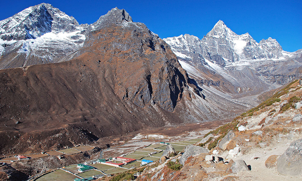
Day 03: Fly to Lukla from Kathmandu and trekking to Phakding
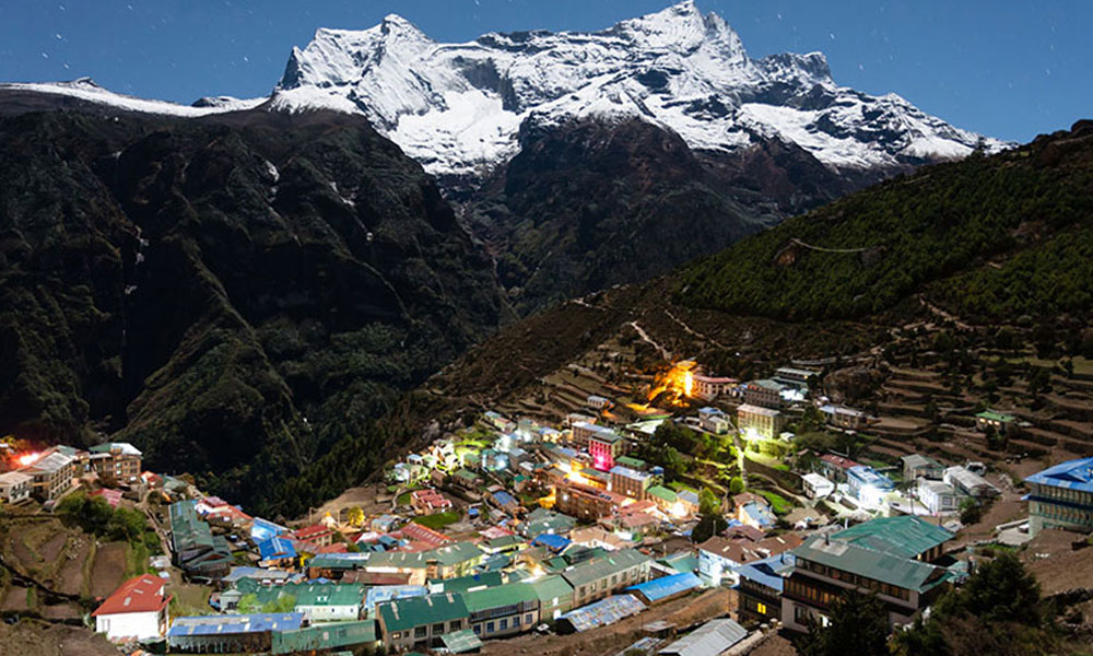
Day 04: Trekking from Phakding to Namche Bazaar
Day 05: Acclimatization and exploration day at Namche
Day 06: Trek to Dole from Namche Bazaar via Phortse Tenga
Day 07: Trekking from Dole to Machhermo
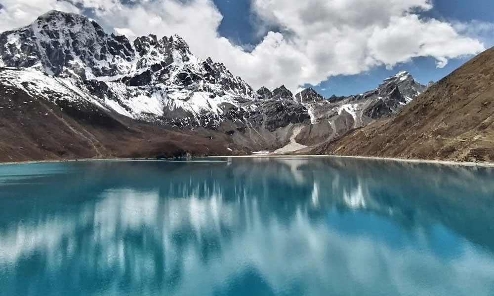
Day 08: Trek to Gokyo Lake
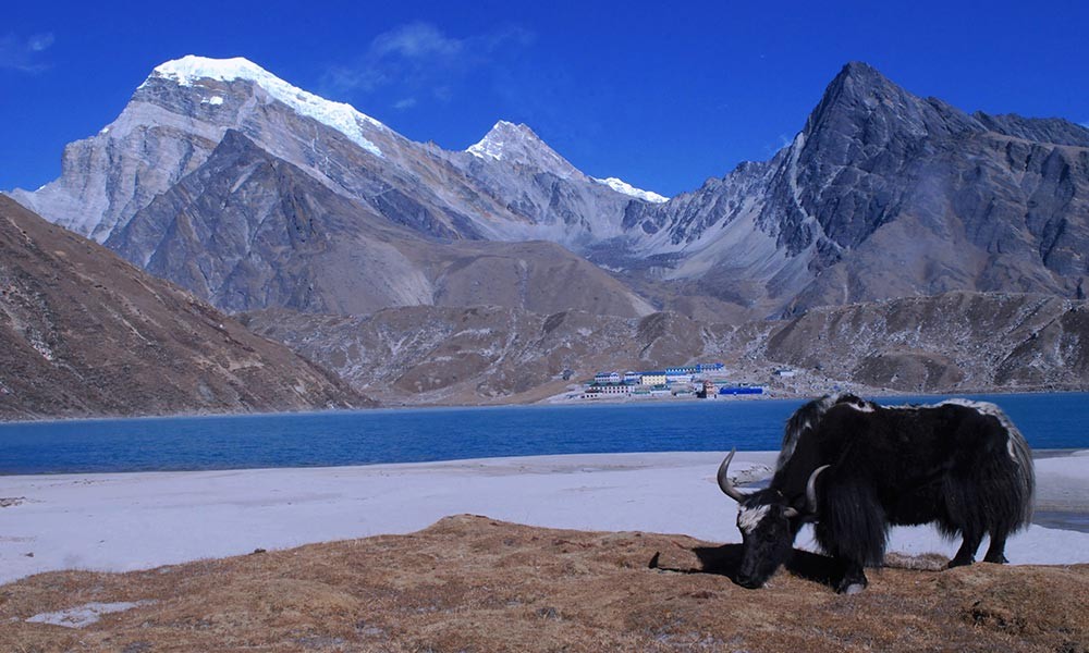
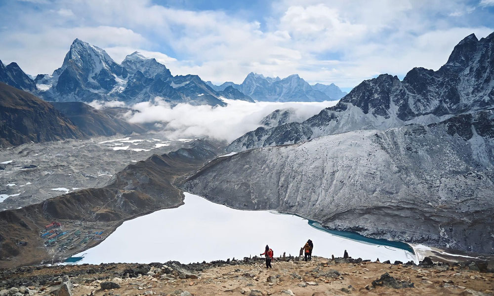
Day 09: Morning hike to Gokyo Ri and exploration day at Gokyo Valley
Day 10: Trekking back to Dole from Gokyo
Day 11: Dole to Namche Bazaar trek
Day 12: Trekking down to Lukla from Namche
Day 13: Morning flight back to Kathmandu from Lukla and leisure afternoon
Day 14: International departure from Tribhuvan International Airport
Gokyo Lake Trek Overview
As the Gokyo Lake is the second most popular highlight in the Everest region, this is one the most visited trekking destinations in Nepal. Depending on your trekking package, your trek will either start directly with the Kathmandu to Lukla flight, or you will enjoy a sightseeing tour prior to your journey in the mountain.
After landing at Lukla, the center point where every adventure in the Khumbu region begins, you will move along the banks of the Dudh Koshi River to reach Phakding. From the next day onward, you will move along the gradually inclining trekking route to reach Namche Bazaar.
Then, diverting from the mainstream trekking route of the Everest Base Camp Trek, you will follow the trails toward Gokyo Valley. Your Gokyo Lake Trek map will then lead you through the charming Sherpa settlements in the valley, like Dole, Phortse Tenga, and Machhermo, to finally reach the pristine glacial lakes.
But, your exciting Himalayan adventure only meets the conclusion after the hike to Gokyo Ri, the highest point of this trek, which will reward you with stunning views of the mountain ranges, glaciers, and valleys down below.
You will then descend down the same trekking route across Dole and Namche to reach Lukla. Your morning flight back from Lukla to Kathmandu will mark the closure of your remarkable Himlayan trek, and you will enjoy a leisurely day at the bustling capital before departing for your home country the next day.
Gokyo Lake Trek Map- Detailed Itinerary Route and Daily Activites
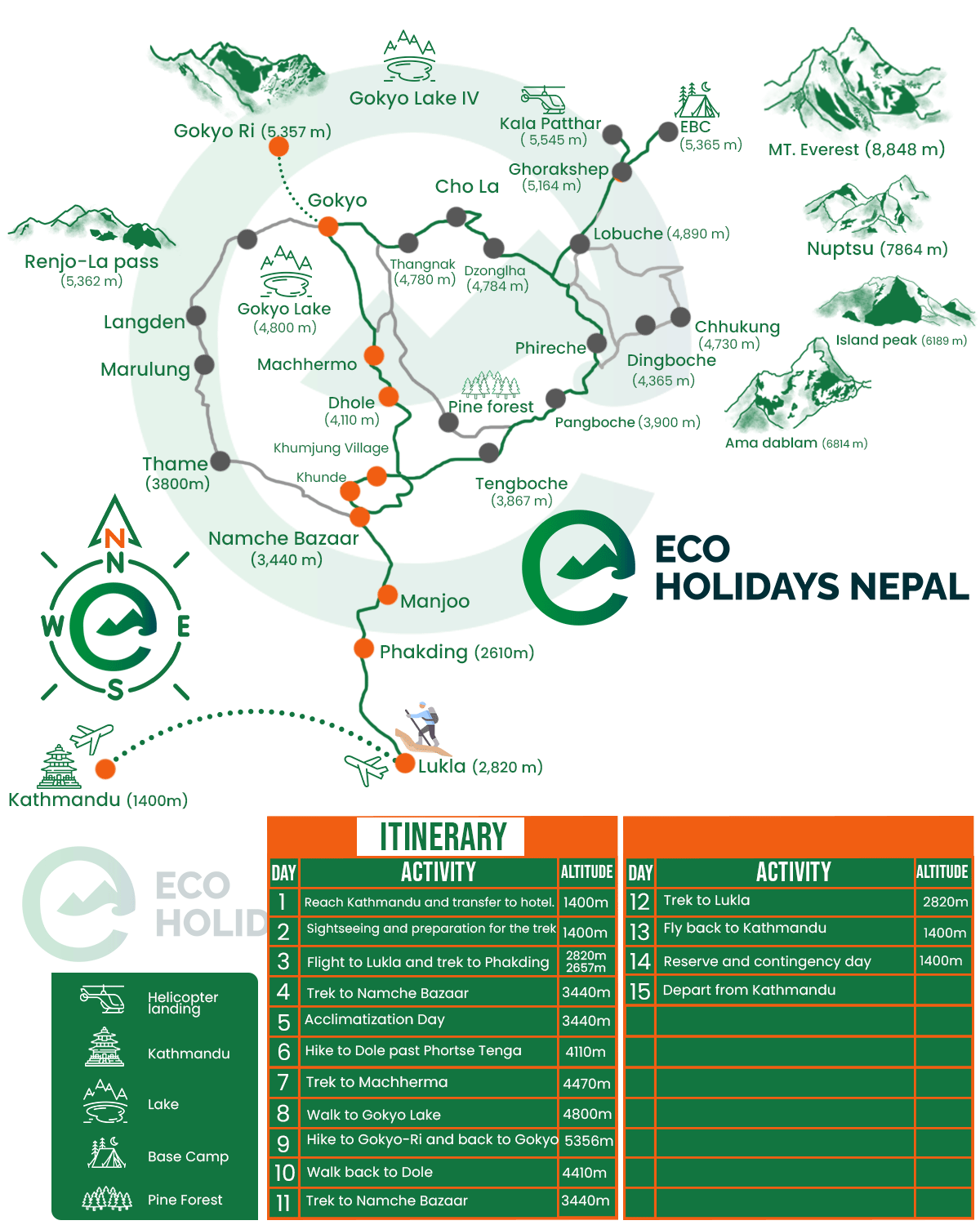
Here is a detailed itinerary plan of the Gokyo Lake Trek map that our 14 Day Gokyo Lakes Trek follows. The trekking map and route are pretty much similar even in packages offered by other agencies as well; however, it may vary if there are any side exploration included.
Day 01: Kathmandu arrival and transfer to respective hotel
Kathmandu Elevation: 1,400 meters/ 4,593 feet
Upon your arrival at the TIA (Tribhuvan International Airport), our staff will pick you at the airport and arrange transport for your swift transfer to the hotel. You can stroll around Kathmandu after getting some rest or visit our office to collect more information about your trek.
Day 02: Options sightseeing tour at Kathmandu and trek preparation
Kathmandu Elevation: 1,400 meters/ 4,593 feet
On this day, you can take part in the optional sightseeing tour that will explore the cultural and heritage sites of this Himalayan country. This day excursion will also take you across some of the major UNESCO Sites in the valley.
This is also the trek preparation day, ready your gear and sort our your luggage for the magnificent journey that is starting tomorrow.
Day 03: Fly to Lukla from Kathmandu and trekking to Phakding
Kathmandu Elevation: 1,400 meters/ 4,593 feet
Lukla Elevation: 2,800 meters/ 9,186 feet
Phakding Elevation: 2,610 meters/ 8,562 feet
Elevation Gain: 1,400 meters/ 4,593 feet
Flight Duration: 35 minutes
Trekking Distance: 6.2 km/ 3.8 miles
Trekking Hours: 3 to 4 hours
In the morning, you will take a scenic flight from Kathmandu to Lukla enjoying the incredible bird-eye view of the Himalayan vista and lush valley below. After landing at Lukla, you will meet the rest of the team and move along the banks of the Dudh Koshi River trekking across Chaurikharka Village and Dudhkoshi Ghat to reach Phakding.
Day 04: Trekking from Phakding to Namche Bazaar
Phakding Elevation: 2,610 meters/ 8,562 feet
Namche Bazaar Elevation: 3,443 meters/ 11,295 feet
Elevation Gain: 833 meters/ 2,732 feet
Trekking Distance: 7.4 km/ 4.6 miles
Trekking Hours: 6 hours
Moving along the ascending route on this day, you will head toward the vibrant Sherpa town of Khumbu, Namche Bazaar. Traversing across several suspension bridges along the route Monjo Village and Sagarmatha National Park, you will follow this mainstream route, catching th first glimpse of Mt. Everest to reach Namche.
Day 05: Acclimatization and exploration day at Namche
Namche Bazaar Elevation: 3,443 meters/ 11,295 feet
On this day, as you have ascended to a significant altitude in your journey, you will take a rest day to adapt to the rising altitude. There are several hiking prospects that you can explore on this day, like Khumjung Monastery, Khunde Village, Syangboche Airstrip, Everest View Hotel, Sherpa Culture Museum, etc.
Day 06: Trek to Dole from Namche Bazaar via Phortse Tenga
Namche Bazaar Elevation: 3,443 meters/ 11,295 feet
Dole Elevation: 4,200 meters/ 13,779 feet
Phortse Tenga: 3,840 meters/ 12,598 feet
Elevation Gain: 757 meters/ 2,483 feet
Trekking Distance: 12 km/ 7.4 miles
Trekking Hours: 6 to 8 hours
Now, leaving the mainstream trekking route of Everest Base Camp Trek, you will head toward the pristine Gokyo Valley. This day’s trail consists of several uphill and downhill sections; you will first descend to Mong La Pass before crossing Phortse Thenga to reach Dole.
Day 07: Trekking from Dole to Machhermo
Dole Elevation: 4,200 meters/ 13,779 feet
Machhermo Elevation: 4,470 meters/ 14,665 feet
Elevation Gain: 270 meters/ 885 feet
Trekking Distance: 7 km/ 4.3 miles
Trekking Hours: 5 to 6 hours
You traverse further inside the Gokyo Valley on your ascending route. Following the praying flags, you will move along the spiritual route and trek past the beautiful high-altitude settlements of Lapahrma and Luza to reach Machhermo.
Day 08: Trek to Gokyo Lake
Machhermo Elevation: 4,470 meters/ 14,665 feet
Gokyo Lake Elevation: 4,800 meters/ 15,748 feet
Elevation Gain: 330 meters/ 1,082 feet
Trekking Distance: 5.7 km/ 3.54 miles
Trekking Hours: 5 to 6 hours
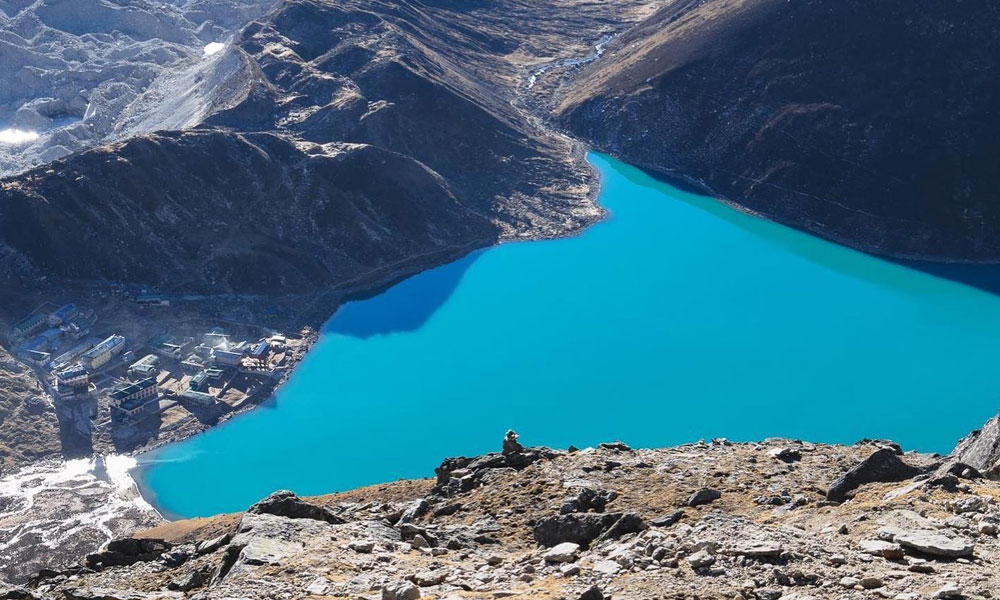
This day’s trek will finally lead you to the main objective of this iconic Himalayan exploration. You will trek for about 1 hour to reach the Phanga Village, and after crossing an iron bridge, you will reach the Logpongo Lake. Following the Ngozumpa Glacier moraines, you will then cross the second lake to reach Gokyo Lake.
Day 09: Morning hike to Gokyo Ri and exploration day at Gokyo Valley
Gokyo Lake Elevation: 4,800 meters/ 15,748 feet
Gokyo Ri Elevation: 5,430 meters/ 17,814 feet
Elevation Gain: 630 meters/ 2,066 feet
Trekking Distance: 1.5 km/ 0.9 miles
Trekking Hours: 1 to 2 hours
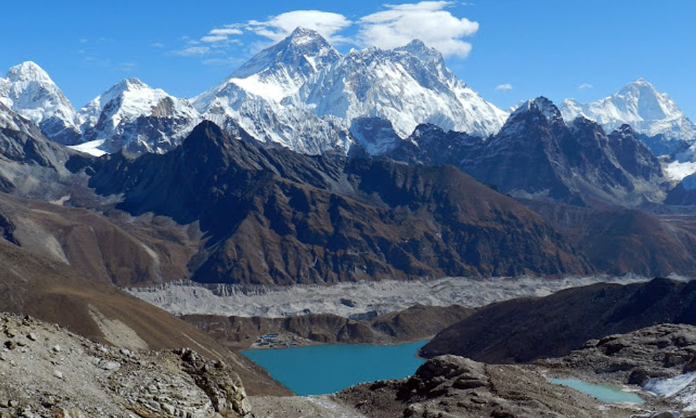
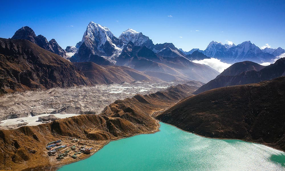
After relishing the peaceful and spiritual ambiance of the Gokyo Lake, this day’s trek will lead you to the vantage point of the Gokyo Valley. From the top of this vantage point, you can enjoy incredible views of the Himalayan panorama of peaks like Everest, Cho Oyu, Lhotse, Makalu, and other surrounding peaks. You will spend another night at Gokyo Village.
Day 10: Trekking back to Dole from Gokyo
Gokyo Lake Elevation: 4,800 meters/ 15,748 feet
Dole Elevation: 4,200 meters/ 13,779 feet
Elevation Loss: 600 meters/ 1,968 feet
Trekking Distance: 14 km/ 8.6 miles
Trekking Hours: 6 to 8 hours
As you have completed your Gokyo Valley Trek, from this day forward, you will make your descent to reach the starting point of your journey. Following the moraines of the Ngozumpa Glacier, you will trek past Phanga and Machhermo to return back to Dole.
Day 11: Dole to Namche Bazaar trek
Dole Elevation: 4,200 meters/ 13,779 feet
Namche Bazaar Elevation: 3,443 meters/ 11,295 feet
Elevation Loss: 757 meters/ 2,483 feet
Trekking Distance: 12 km/ 7.4 miles
Trekking Hours: 5 to 6 hours
Today’s return trek will take you back to the Sherpa capital, where you will spend one more night enjoying the amicable vibrance. You will traverse across Mong La Pass and Phortse Thenga to reach Namche Bazaar, where the majestic views of Everest will greet you.
Day 12: Trekking down to Lukla from Namche
Namche Bazaar Elevation: 3,443 meters/ 11,295 feet
Lukla Elevation: 2,800 meters/ 9,186 feet
Elevation Loss: 643 meters/ 2,109 feet
Trekking Distance: 13.5 km/ 8.3 miles
Trekking Hours: 6 hours
This is the final day of the trek in your exhilarating Himalayan journey; you will leave the Namche Bazaar behind and move along the banks of the Dudh Koshi River. Enjoying the incredible natural scenery, you will trek past Phakding to reach Lukla.
Day 13: Morning flight back to Kathmandu from Lukla and leisure afternoon
Lukla Elevation: 2,800 meters/ 9,186 feet
Kathmandu Elevation: 1,400 meters/ 4,593 feet
Elevation Loss: 1,400 meters/ 4,593 feet
Trekking Hours: 35 minutes
Today, you will take a morning flight from Lukla to return back to Kathmandu. Enjoying the magical Himalayan views and lush landscapes, you will land in the capital city. Then, after the hotel transfer, you will have a leisurely afternoon to spend your day sightseeing around the city.
Day 14: International departure from Tribhuvan International Airport
Kathmandu Elevation: 1,400 meters/ 4,593 feet
According to your flight schedules, our staff will pick you up from your respective hotel and transfer you to the airport terminal. Make arrangements to reach the airport at least 2-3 hours before the actual flight. Have a safe journey.
What is the Difficulty Level of Gokyo Lake Trek?
The Gokyo Lake Trek is one of the moderate-grade trekking adventures in the Himalayas. Although there aren’t any strenuous sections along the trekking, nor will you need any technical skills to navigate the route, this is still a high-altitude exploration in the Everest region.
This iconic, pristine glacial lake journey will take you across the remote terrains of the hidden valley in the region and relatively high altitude points. Two of the most significant hurdles you have to be on the lookout for are altitude gain and the trekking distance/period.
While following the Gokyo Lake Trek map, you will start your trekking adventure from the Lukla (2,800 meters). Then, you will gradually clib to higher altitudes of the journey after diverting toward Gokyo Valley from Namche Bazaar (3,443 meters).
The journey up ahead then takes you along the high elevation points of the valley above 4,000 meters, and you will reach the highest point of the trek at Gokyo Ri (5,430 meters). So, as the altitude gain is significant, the risk of altitude sickness is also significantly high if you don’t acclimatize properly and stick to appropriate precautionary methods.
Similarly, the you will trek about 92 km (57.16 miles) in this remarkable Himalayan excursion. You will have to walk for about 6 to 7 hours during each trekking day in this adventure. If you are adequately prepared for the physical demand of the trek, then it can be hard for your to enjoy the experience.
Is This Trek Right for Me?
Do you have at least a basic level of fitness and good health? Then, certainly, this exciting exploration prospect of the Everest region is an ideal trekking option for you. This journey to the pristine hidden valley of the Everest region is something you will cherish for your lifetime.
As this trek is labeled as a moderate Himlayan exploration, you don’t have to deal with physically exhausting high altitudes and Himalayan passes. You will just navigate along the gradually inclining route of the Everest region and mostly explore the destinations that are below 5,000 meter.
If you are motivated and feel confident about your physical capabilities, you can surely take part in this exciting adventure of the nort-eastern part of the Himalayas. The overall success rate of the Gokyo Lake Trek is 98% to complete 100%; if you want to relish a different side of the mainstream Everest region, you should definitely do this trek.
**Note: If you have any kind of medical conditions, you can consult your doctor and trekking guide to decide whether this trek is suitable for you or not**
You may also like:
Is There Way to Prepare Efficiently to Overcome Difficulties of Gokyo Lake Trek Map?
Yes, most certainly, there are some efficient ways to properly prepare for this exciting journey in the Everest region. Like we discussed, as this your Gokyo Lake Trek map follows the elevating route toward Gokyo Valley leaving the mainstream route of Everest Base Camp Trek at Namche Bazaar, you should be prepared for remoteness factor of the trip.
You will most trek on the rugged landscapes of this hidden valley with several steep sections. Thus, you first priority while training for the trek should be ephasized on strength and endurance build up as well as developing the stamina reserve.
Focussing on these aspects will make your long day of walk more easier and you will find yourself more resilient toward the physical demand of the trek. It is recommended that you should begin your trek 3 to 6 weeks before the actual trek. However, you can decide on the duration of the training depending on how well you can fit the regime in your daily schedule.
Strength Training Exercises: Squat, Deadlift, Plank, Bicep Curl, Lunge, Push Up, Pull Up, Overhead Press, Upright Row, Leg Press, Calf Raise, Leg Raise, etc
Stamina Training Exercises: Jumping Jack, Mountain Climber, Woodchop, Stair Climbing, Jumping Rope, Jogging, Cycling, Swimming, etc
**Note: Pratcise hikes are one of the most efficient ways to prepare for high altitude trekking adventures. You will be able to understand the physical demand of the excursion as well as have the opportunity to test out your gear**
When is the Best Time to Enjoy This Trek?

If you are looking for comfortable and immersive experience, we recommend you to explore this exciting route during the high seasons like spring (March to May) and autumn (September to November). The climatic conditions of the high Himalayan regions are most stable during this period and the lush landscapes are just simply enchanting.
Spring in particular is known for its unparalleled natural beauty, the whole lower trekking region is covered with Rhodoneron and other wild flowers. Similarly, the flora and fauna of the Sagarmatha National Park are more active during this peak point of nature. That means, more opportunity for birdwatching and wilderness exploration.
Similarly, autumn is known for the most stable climatic conditions and the clear visibility to enjoy the epic panorama of the Himalayan vistas. This season also houses some of the grandest festivals in this Hindu country and you will have the opportunity to immerse in the colorful vibrance of those celebration.