
- Where is Mount Everest Located on a Map, and How Old is It?
- How High is Mount Everest?
- Geography and Climate
- Accessibility
- First-Ever Ascent of 1953
- Hazards of Climbing Mount Everest
- Why Do Mountaineers Prefer Southeast Ridge From Nepal for Everest Expedition?
- How Long Does Climbing Mount Everest Last?
- Exact Location of Mount Everest with GPS Co-ordinates:
- Location of Mount Everest in China Side
- Can you see Mount Everest from Kathmandu?
You might have at least heard once about the highest snow-clad wonder on the planet Earth, Mt. Everest, which stands at a staggering elevation of 8,848.86 meters (29,031.69 feet). But do you know where is Mount Everest located?
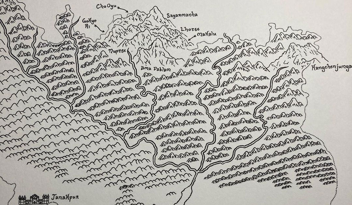
Known as the ‘‘Top of the World’ and ‘Roof of the World’ is the highest snowy wonder of the world that shares a border with Tibet and Nepal. Like other peaks in the Himalayas, this highest peak in the world has been revered as a holy peak by the natives of both countries. The Tibetan name for this incredible peak is Chomolungma, which can be translated to the ‘Goddess of the Valley.’ In Nepal, this marvelous snow-clad Himalayan figurine is known as ‘Sagarmatha’, which means ‘Peak of Heaven’.
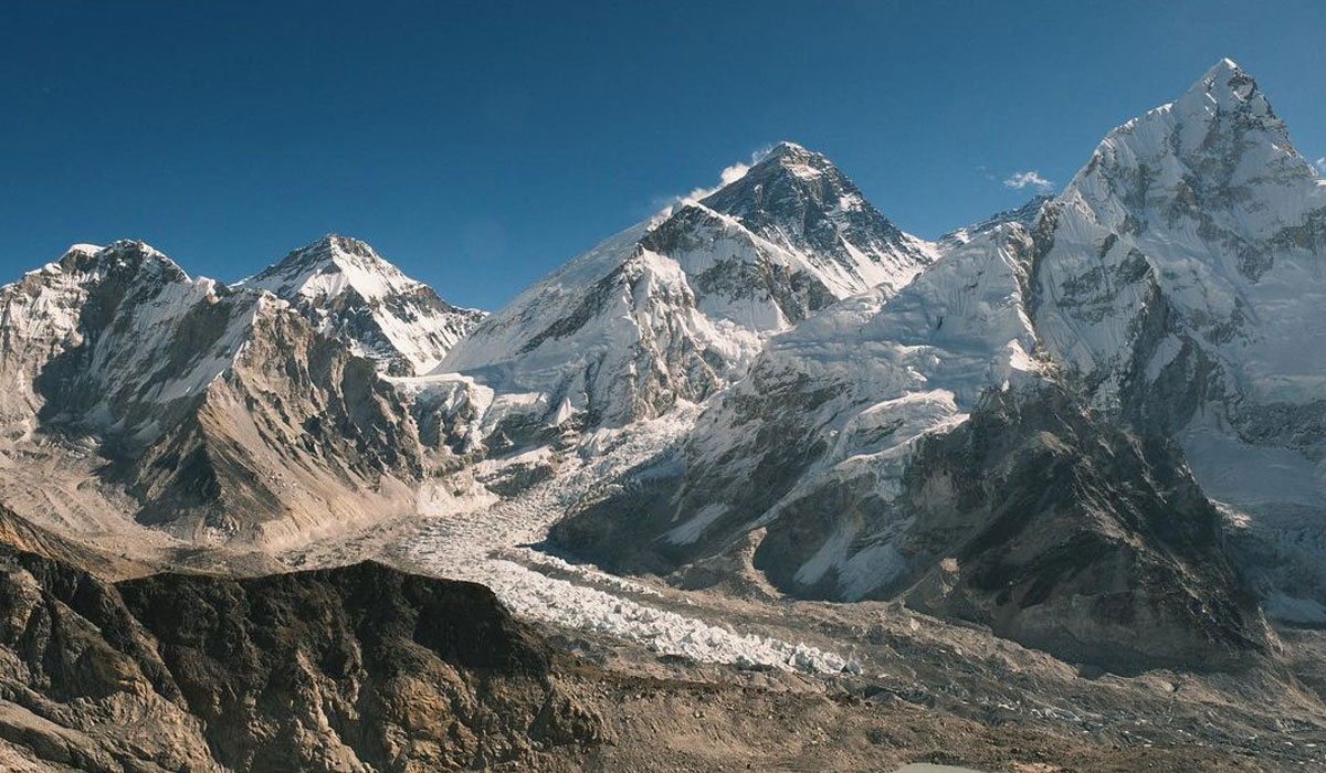
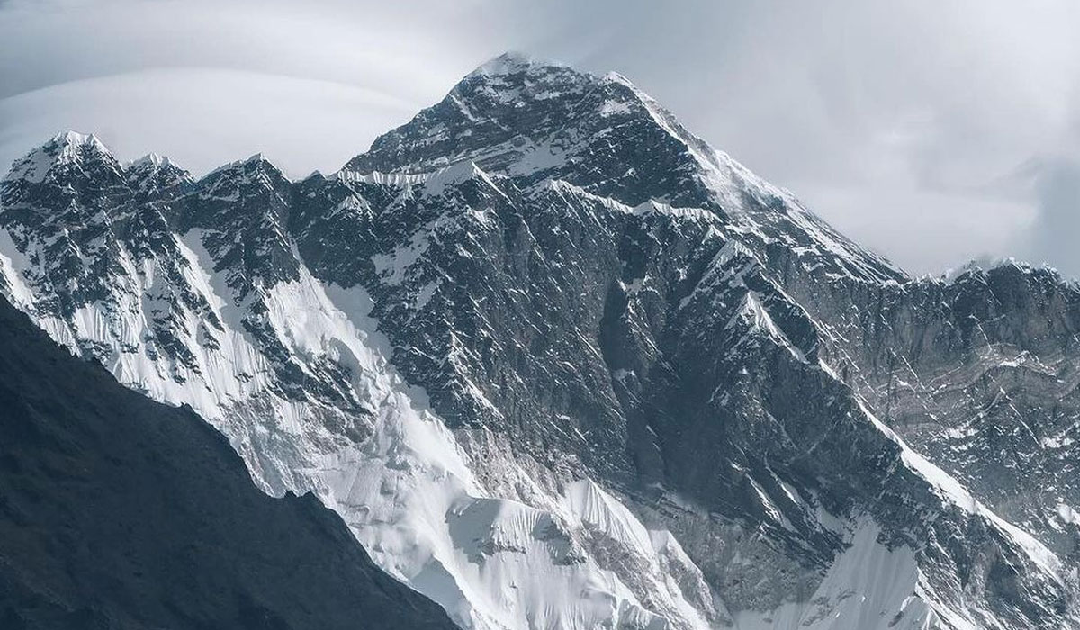
This incredible peak of the Himalayas in the Mahalangur section towers over other pristine peaks in the great range that stretches across six countries: Nepal, India, China, Bhutan, Afghanistan, and Pakistan. The conquest of this tallest pristine peak in the world is the lifelong dream of every mountaineer. Standing at an elevation of 8,848 meters (29,032 feet) from sea level, this peak isn’t just marvelous grandeur on earth but also serves as the crucible landmark for courage and quest.
Where is Mount Everest Located on a Map, and How Old is It?
This magnificent peak is located at the crest of the Great Himalayas of South Asia and is on the border of Nepal and Tibet. The latitude of Mt. Everest is 27.9881° N, and its latitude is 86.9250° E.
In Nepal, it is located inside the Sagarmatha National Park (est. 1976) in the Solukhumbu district of Nepal. On the Tibetan side, the range is located in the Xigaze's Tingri County.
Its identification as the tallest peak in the world was not recognized until 1852. Before that, Mt. Kanchenjunga, another Himalayan peak in the eastern part of Nepal at an elevation of 8,586 meters (28,169 feet), was considered the tallest peak in the world.
Mt. Everest, before that, was named Peak XV. The Governmental Survey of India presented the facts about this magnificent peak being the highest peak in the world in 1952. Then, in 1865, the peak was officially renamed to Mt. Everest in honor of the British Surveyor General of India (1830 to 1843), Sir George Everest.
The scientists have estimated Mt. Everest to be at least 50 to 60 million years old and is considered a youngster by geographical standards. The entire Himalayan range was thrust upward by the tectonic action between the Indian and Eurasian tectonic plates.
Thanks to the collision, the tectonic plates pushed the massive rock formation that later formed the highest mountain in the world. One of the fascinating things about this collision is that the tectonic force is still at work today, and it pushes the summit of Mt. Everest by a quarter of an inch every year.
How High is Mount Everest?
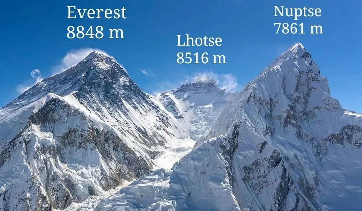
Mount Everest is the highest peak in the world and stands at an elevation point of 8,848.86 meters (29,032 feet). But, as we learned that the Indian and Eurasian tectonic plates’ still active collision pushes the peak by a quarter of an inch every year, is the height still relevant today?
According to the most recent joint survey of Nepal and China, the new height of Mt. Everest is 8,848.86 meters (29,031.69 feet). In 1854, the Indian survey team determined the height of the tallest mountain in the world to be 8,848 meters (29,029 feet).
However, the Chinese survey team in 2005 measured the peak at 8,844.43 meters (29,017 feet), which was nearly 13 feet lower than the Indian estimation. Then, in 2020, a joint survey of both Nepal and China agreed on the new official height of the mountain, 8,848.86 meters (29,032 feet).
Geography and Climate
Mt. Everest, located in the Himalayas, sits on the 2,414 km (1,500 miles) mountain system that took the range formation after the collision between the Indian and Eurasian tectonic plates.
The peak of this highest peak in the world has three somewhat flat sides and is shaped like a three-sided pyramid. The lower parts of this mountain comprise of metamorphic schists and gneisses; they are covered with igneous granites that give the sandy and rocky complexion.
However, as you reach the upper part of the mountain, the marine sedimentary rocks take over; this is also true for the other surrounding peaks in the region. This suggests that this incredible peak was once submerged under the ocean.
The temperature of the mountain changes depending on the season; although there is comfortable weather lower part of the region, the climatic conditions at the alpine altitudes are cold.
Even at the Everest Base Camp, which is at an elevation of 5,364 meters (17,598 feet), the temperatures can drop to -3°C during the summer seasons and can drop upto -17°C in the winter.
During the scaling, the temperature near the summit can drop as low as -60°C, and even in the warmest month of the year, July, the temperature near the summit is -18°C. The temperature rises above the freezing margin on the mountain.
Similarly, the weather at such incredible heights can be unpredictable at any moment. Ranging from howling winds to raging storms can hit the slopes without even a warning, and when the weather conditions turn bad, the visibility is poor, which makes maneuvering very difficult.
Accessibility
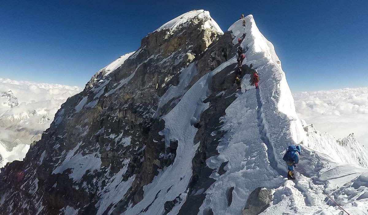
Although the mountaineering pioneers have created more than 17 different climbing routes to the summit of the tallest mountain in the world, two routes are the most popular and safest way to the summit.
The Southeast Ridge route from Nepal, where is mount Everest located was created by the first ascenders of the mountain, Tenzing Norgay and Edmund Hilary, in 1953. The north from the Tibetan side is called the North Ridge. This route was taken by the British expedition team in 1924, and the English mountaineer George Mallory disappeared on the slope of the mountain.
Mt. Everest expedition from the North Ridge was only completed in 1960 by a Chinese expedition team. The scaling of the mountain is also slightly easier from the North Ridge as the climbers can take jeeps all the way to the base camp. However, the climbers have to travel several kilometers of terrain at significant altitudes from this route.
On the south side, the climbing route takes you across the most popular base camp adventure in the world, Everest Base Camp Trek. The expedition journey from the Nepali side starts with a flight from Kathmandu to Lukla.
Then, moving along the popular highlights of the Khumbu region, like Namche Bazaar, Tengboche, Dingboche, Lobuche, and Gorakshep, climbers finally reach the base camp where they prepare for their Everest expedition.
First-Ever Ascent of 1953
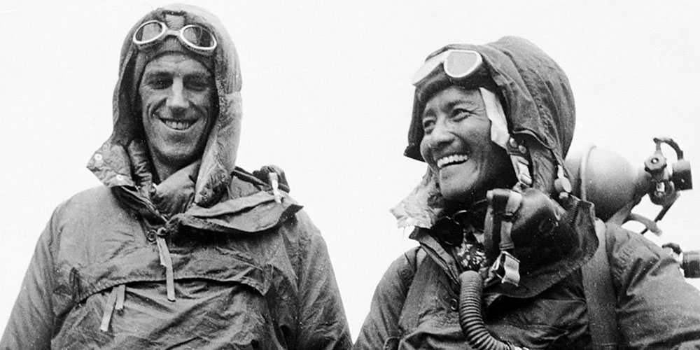
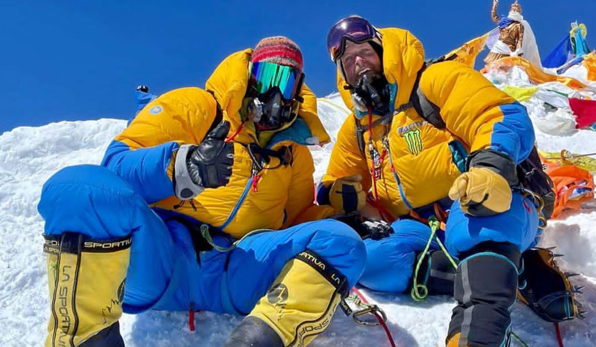
Sir Edmund Hillary and Tenzing Norgay Sherpa became the first-ever human beings to step foot on the summit of the highest peak in the world in 1953. In an expedition sponsored by the Royal Geographical Society and Alpine Club, the British expedition team was led by John Hunt.
It was 11:30 A.M. on 29th May 1953 when these two mountaineering pioneers engraved their names in history. Sir Edmund Hillary, who was born on 29th July 1919 in Tuakau, New Zealand, had scaled several mountains in New Zeland and Europe before conquering Everest.
Hillary’s father was a beekeeper, and he himself pursued a career in the same field during the early part of his life. But, on hearing the call of the mountain, the New Zealander mountaineer started scaling the Southern Alps during his high school years.
After World War II, Hillary joined New Zealand’s expedition team to the central Himalayas in 1951, determined to successfully scale the tallest peak in the world. In the same year, he then joined the British reconnaissance expedition on the southern flank of Everest.
The New Zealander mountaineer also did other expeditions to Everest during the early 1960s but never tried to scale the mountain all the way to the top. Hillary was knighted shortly after the successful Mt. Everest expedition during his return to London. He also served as New Zealand’s High Commissioner to Nepal, India, and Bangladesh from 1985 to 1988.
Tenzing Norgay Sherpa born on 29th May in Khumbu, where is mount Everest located, had an interesting early life before he was renowned as a world-class mountaineer who conquered the highest mountain in the world.
Born at the foothills of Mt. Everest, he spent his early life in Khumjung, and in his teen years, Norgay moved to Darjeeling seeking for a better life. Even moving farther from the Himalayas, he never lost his connection with these majestic peaks.
The legendary mountaineer was only 19 years old when he joined the 1935 British expedition team led by Eric Shipton. Then, in the next few years, Norgay participated in several other Everest expeditions, earning fame as a reliable guide.
Tenzing Norgay Sherpa was promoted to Sirdar, an organizer of porters, after World War II. He made two attempts on the southern route of Everest with the Swiss Expedition Team in 1952; Norgay was Sirdar in both of these expeditions.
In the British expedition of 1953, Norgay was also a Sirdar and was paired with Sir Edmund Hillary for the second summit push; the rest is history.
Hazards of Climbing Mount Everest
The Mount Everest expedition is considered one of the most demanding and challenging endeavors in the world. Of course, scaling the highest peak in the world comes with a set of challenges and risks that mountaineers need to overcome.
Everest expedition has a success rate of about 60% to 70%, and the fatality rate during the expedition is about 4.4 deaths per year since 1922, according to the Himalayan Database. However, the Everest expedition is not as deadly as the other 8,000-meter class mountain expeditions, like Annapurna (8,091 meters)- with 32 deaths per 100 successful summits, K2 (8,611 meters)- with 23 deaths per 100 successful summits and Nanga Parbat (8,126 meters)- with 21 deaths per 100 successful summits.
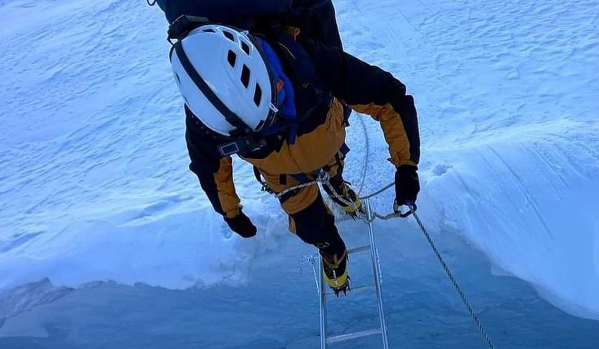
Still, its extreme altitudes, treacherous slopes, and unforgiving weather make the Everest expedition one of the most challenging expeditions in the world. During the scaling of the tallest snow-capped peak in the world, mountaineers have to traverse through the death zone (area over 8,00 meters with limited oxygen).
These death zones are one of the most deadly sections on the 8,000-meter class mountains, and of course, the tallest peak in the world has a more stretched version of this deadly space. The death zones are so dangerous that the human body cells start dying one by one, and minute by minute, the Everest expedition is literally a race with time.
That's why mountaineers are not recommended to stay for more than 16 to 20 hours inside the death zone. So, summit push day is a challenging and dangerous endeavor where climbers have to consider about every time tick.
Similarly, due to extreme altitude, mountain sickness is another major challenge in this greatest expedition of the world. During mountain scaling, climbers struggle with the milder form of altitude sickness, Acute Mountain Sickness (AMS), to the deadliest and life-threatening variants like High Altitude Cerebral Edema (HACE) and High Altitude Pulmonary Edema (HAPE).
At the summit of Everest, the oxygen saturation level drops to 33%, which makes even a simple, straightforward climb physically exhausting. Besides mountain sickness, falls, avalanches, exhaustion, exposure, and hypothermia are some of the major leading causes of the death of mountaineers on the slopes of the mountain.
You may also like:
- 13 Things to Know before Everest Base Camp Trek
- How do you get to Everest Base Camp without trekking?
- Where is the best place to see Mount Everest?
Why Do Mountaineers Prefer Southeast Ridge From Nepal for Everest Expedition?
After learning where is Mount Everest, you might also want to learn which of the climbing routes to the summit of this highest peak in the world is more popular. Although the North Ridge on the Tibetan side has easy accessibility as climbers can enjoy a comfortable drive all the way to the base camp, the route on Nepal’s side is more popular among mountaineers.
Not just the Everest expedition, the exploration on the Nepali side of the Himalayas is quite a grandeur as it alone houses 8 of the 14 highest peaks in the world (8,000-meter class mountains). Regardless of the expertise level of the mountaineering enthusiast, this beautiful country nestled in the Himalayas offers remarkable scaling adventures to everyone.
Nepal is also a top choice when it comes to Himalayan trekking adventures, this in particular, is one of the reasons why mountain expeditions to the summit of Everest are popular from the Southeast Ridge.
During the scaling from the Nepali side, mountaineers get to experience the world’s most popular and highest base camp trekking adventure. It is no news that the natural allurements of this beautiful landlocked are unparalleled, and the climbing route also lets the climber to experience the authentic culture of the Sherpa communities.
These Sherpa communities have made a massive contribution to the development of the mountaineering industry in the world and are known as fearless guides who have been leading expeditions on the treacherous slopes of the mountain for over a century.
Climbers get the opportunity to enjoy a cozy and comfortable teahouse trekking experience on this route and also get the opportunity to traverse across the conserved area of Sagarmatha National Park (est 1976), which is known for its rich Himalayan bio-diversity.
The Nepali side also has helicopter facilities that are used to evacuate and rescue the climbers in emergencies. However, in the autonomous region of China, helicopter operations are not available.
How Long Does Climbing Mount Everest Last?
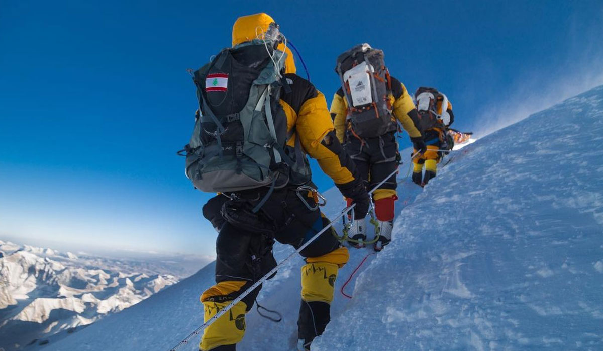
The normal duration for the Mount Everest expedition is around two months. During the expedition from the Southeast Ridge on the Nepali side, mountaineers have to follow 12-14 days worth of Everest Base Camp Trek route to reach the base of the mountain.
The real challenge begins upon reaching the base camp where climbers spend several weeks ascending and descending between the camps on the slopes to properly adapt to the alpine environment. Even though it takes approximately 5-6 days to reach the summit of this incredible peak, for safety, mountaineers prepare a significant amount of summit bids to adapt to the environment.
After several weeks of ascending and descending between the camps, mountaineers push all the way to Camp IV (7,950 meters), which is situated near the death zone. Climbers start using bottled supplementary oxygen after reaching this altitude due to extreme altitudes and low oxygen levels.
Mountaineers adapt to this highest acclimatization point on the slope of the mountain before the summit push. Failing to properly adapt to the new altitude can lead to severe forms of altitude that at such extreme altitudes, mean a death sentence.
Thus, the expedition itineraries are tailored very carefully considering the risk factors and the need to adapt to the alpine altitudes before challenging the death zone on Everest. The more time mountaineers put into acclimatization, the higher the probability of a successful summit.
Has the height of Mount Everest increased (in reality)?
Yes, nearly a meter.
After years of debate between the two countries, Nepal and China jointly announced the official new height of Mount Everest as 8848.86 m on 8th December 2020.
So, Mount Everest's height has been increased by 0.86 m. Isn't it nearly a meter more hard work for mountaineers to reach the apex?
Exact Location of Mount Everest with GPS Co-ordinates:
China’s National Surveying and mapping administration provided the exact location of Mount Everest in 2005. Longitude and Latitude are 86˚55’ East and 27˚59’ North, respectively.
Location of Mount Everest in China Side
Mount Everest in China is Tibet’s Tingri country in the Xigaze area. Reaching Everest from the Chinese side is much easier as there is a road to reach the Chinese Everest base Camp. So, climbing from this region is always cheaper.
Only a few people climb Everest from the Chinese side because of political restrictions and other factors. One reason is that rescue operations are complicated, and even helicopters don’t have permission to fly from this side.
Can you see Mount Everest from Kathmandu?
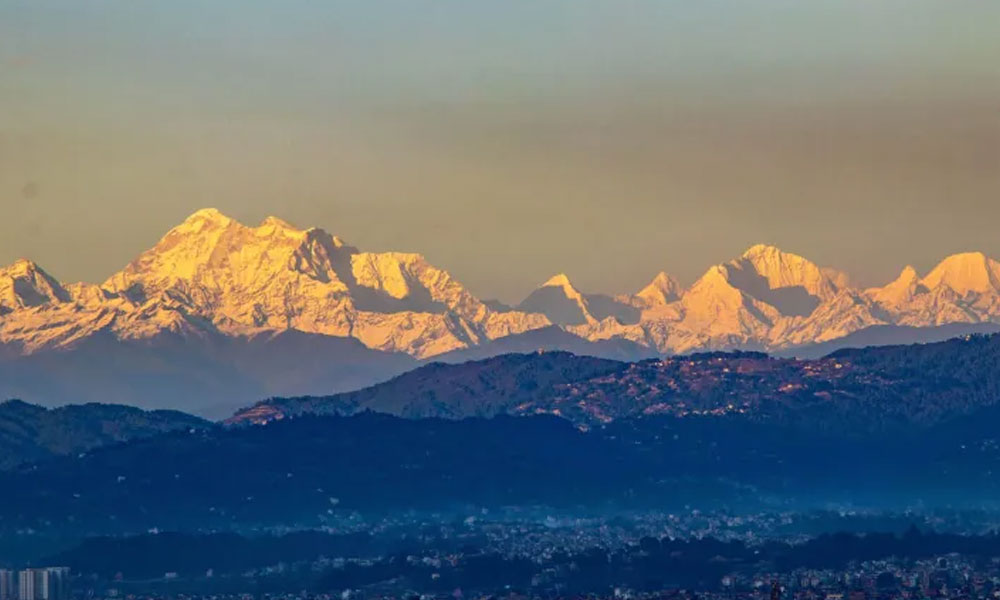
If we talk about the air distance between Kathmandu and Mount Everest, then it is approximately 160 km.
So, now the question arises, is it possible to see Everest from Kathmandu?
And the answer is ‘Yes. ‘ Kathmandu Valley seems lucky as high hills surround it because as we climb it, we start getting wonderful mountain views during spring, autumn, and winter (and whenever there is a crystal clear sky).
Among other hills, Chandragiri Hill is the nearest and the perfect destination for mountain views if you’re in Kathmandu. It offers more than 270° mountain views, including the Himalayan ranges of Nepal and the Mahalangur range (Mount Everest). So, on a crystal clear day, you could see Mount Everest from this place.